An Article by Rick Ray
Flying around Woodrat Mountain takes many forms. From the first exhilarating flights of the new student, to magical glass offs, to the first venturing afield out to LongSword winery, there are many rites of passage that we move through as we develop as a pilot. We remember the wonder of that first thermal flight as suddenly we started going up. We were catching a glimpse of the invisible power around us as the atmosphere moves and flexes. Through trial and error, mentoring and study, we soon became proficient at finding a second and then a third thermal. Our flights started lasting longer and longer. We started getting higher and higher on the better days. Then, under the tutelage of a mentor, we made the trip out to LongSword winery. As our skills advanced and we could bumble about the valley on our own, seemingly at will, our world shrank, until the Ruch area wasn’t big enough to hold us. We wanted to explore.
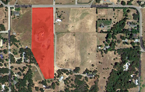
The topic here is about flying from Woodrat to Donato’s house in Talent, a distance of about 10 miles. It is not a long flight in terms of distance but it is a significant flight in terms of the skills and judgment required to safely accomplish. Safety considerations, airspace realities, landing zone accessibility, thermal and lift locations are going to dictate how we responsibly navigate those 10 miles.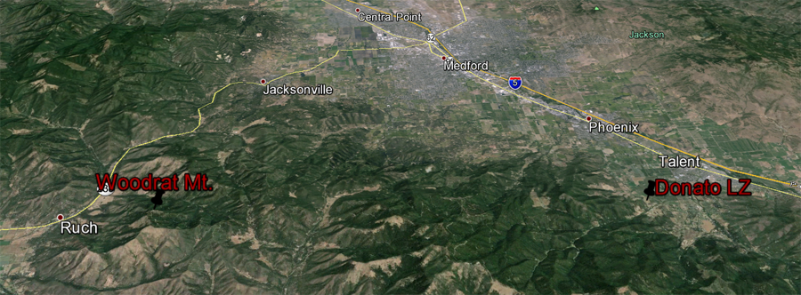
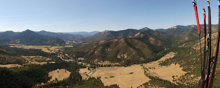
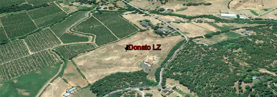
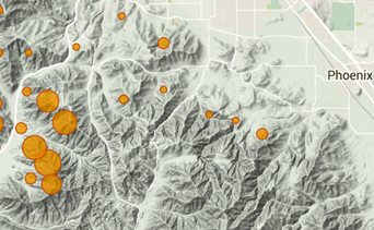
On the left you can see Woodrat. On the right, we see Donato’s house. That is our goal. So how do we get to Donato’s?
For this discussion, we are going to fly from Burnt Ridge on a TYPICAL WEST VALLEY FLOW DAY at Woodrat. North flow days around the Woodrat Mountain area yield a different dynamic and that is not covered in this material.
The short 10 mile flight to Donato’s is not a magic carpet ride and there are no guarantees that you will pull it off if you follow this guide. However, we have had hundreds and hundreds of pilots in competitions and free flyers that have made it to Donato’s over the years. A compilation of the track logs of many of these flights can be found on Michael von Kanel’s website.
Here is the raw data from his site with all the thermal lift locations marked in blue. These are locations where people have found lift. Don’t get excited yet!
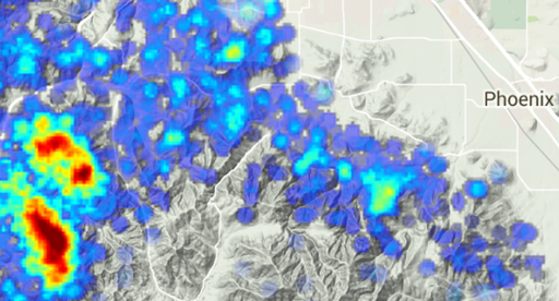
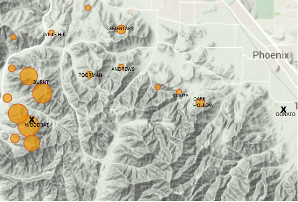
If we then use the toolbar and uncheck ‘show thermals’ and check ‘show hotspots’ then we get a map that looks like this.
If we then superimpose the Woodrat waypoint list then we get a map that looks like this. Note that for the most part, the hotspots and the waypoints coincide.
.
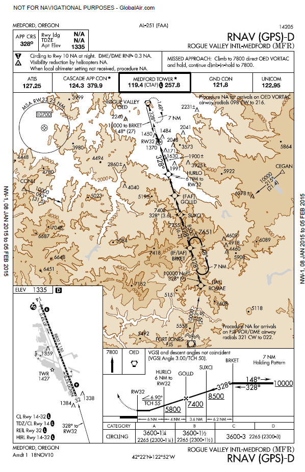
Now we are getting somewhere. We have some of the elements that we need to create a plan whereby we are going to fly to Donato’s. But, first we need to add another very important detail: Medford AIRSPACE. Medford is a Class E airspace and there are APPROACH CORRIDORS IN THE NEAR VICINITY TO DONATO’S.
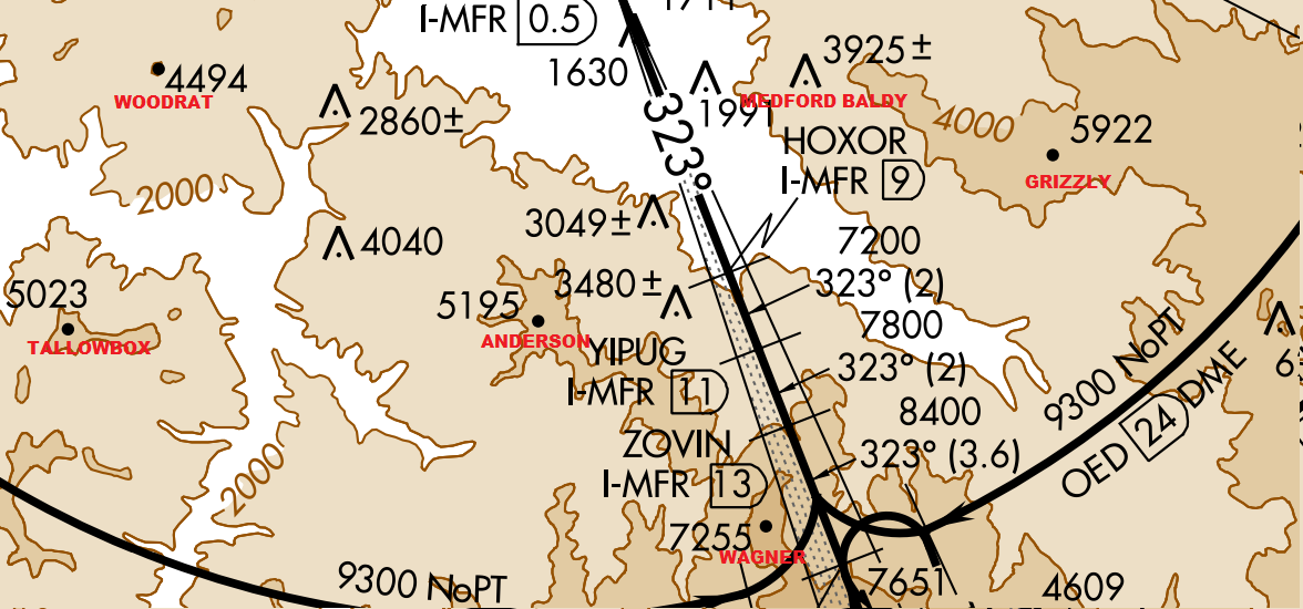
Note that the approach corridor is in near proximity to Donato’s. If we take the sectional waypoints and put them on Google, then it looks like this.

NOTICE SEVERAL CRITICALLY IMPORTANT POINTS.
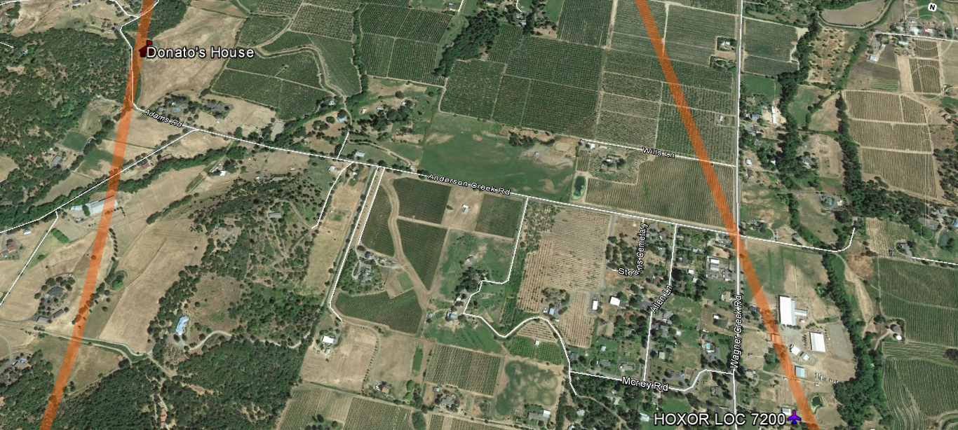
1.The descent corridor is in close proximity to Donato’s house. The approach corridor comes down from the vicinity of Mt. Ashland and Wagner Butte and follows the Wagner creek drainage towards Talent and Medford. The white line shown is a generalized glide line. The important point is that descending aircraft come through the drainage, dropping down from the high ground in the West and traversing the area in the near vicinity of Donato’s house.
2. The elevation at Donato’s house is approximately 2000MSL. The airplanes near his house are descending, crossing from West to East, at approximately 7200 MSL.
3. The further you get out into the main Medford valley towards I-5 then the lower the planes are.
WHAT ARE THE IMPLICATIONS OF THE AIRSPACE AND HOW DOES IT IMPACT OUR TRIP TO DONATO’S?
At Woodrat, we are near the edge of the Medford airspace. Woodrat is not in the keyway extension.
We are flying to the very edge of an active descent corridor. WE MUST FLY RESPONSIBLE. We don’t break airspace by flying towards Medford. We don’t break airspace by flying out towards the I-5 corridor. We don’t break airspace by encroaching into the airplane descent altitudes near Donato’s. We land at Donato’s located immediately this side of the corridor. We make sure that that landing approach is less than 5000 MSL and is made from the Southwest edge of the Anderson Creek/Wagner Creek drainage.
HAVING ASSEMBLED THE PIECES, LET’S FLY TO DONATO’S FROM WOODRAT VIA BURNT RIDGE.
Burnt Ridge is the interface zone between the Applegate Valley in which Woodrat is located and the Rogue River Valley in which Medford and Donato’s is located. On a typical WEST VALLEY FLOW day at Woodrat, it is a convergence zone . Winds are coming up from the Ruch side from the West and from the Jacksonville /Medford side from the North. The convergence zone that results from these clashing windflows often produces incredible climbs. Sometimes the climbs can be turbulent as the thermals push up through and around the competing windflows. Remember that convergences always have a windward and a leeside and as the altitude changes these can reverse places with an accompanying horizontal wind sheer. The thermals at Burnt tend to slide up the interface zone while being deflected towards the weaker side of the convergence. For example, if the Jacksonville push is stronger, the thermal inclination during the climb tends toward Ruch and visa versa.
1. BEFORE YOU LAUNCH BE FAMILIAR WITH THE NO LAND AREAS! There are three located along the route towards Donato’s. It is Your responsibility to know where these are and to avoid them otherwise you put our flying site at risk by creating ill will and the possibility of bad reports. See RVHPA LZ information at http://bit.ly/rvhpa-lz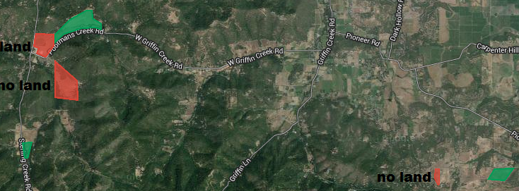
2. Look at the hotspot map from earlier. This will give you and idea of where the more consistent lift has been found. You will want to string these together like the beads on a necklace. However, there often is a surprising amount of convergence lift to be found on the way to Donato’s. I think that we see this in the numerous lift sources on one of the earlier maps.
3. When to start? When do I leave the Woodrat area to go towards Burnt? The higher the better. You do not want to get to Burnt below ridge top! If the Jacksonville flow is strong and you arrive below ridge height, you would be inside the rotor zone and close to the ground. A bad place to find oneself! Get to Burnt above ridge height! The higher the better. Lower class gliders should have at least 5000 feet at Woodrat before attempting the crossing to Burnt. Higher is good.
I usually aim for the Burnt waypoint and then troll back and forth along Burnt ridge between Hwy 238 and the waypoint until I hit lift. That is, unless Hayden is there. Then, I just follow Hayden. Don’t leave Burnt to go on towards Donato’s below 5500. It very seldom pays off. Patience is the name of the game. Wait until you get the great climb. The higher the better. It gives you more options later in the course. Leaving Burnt, I usually head towards Portman’s or Cemetery waypoints because they also happen to be hotspots.
4.CAUTION. Notice that even on the general thermal map that very little lift is found in the fingers and spines as you move towards Donato’s. I have marked them with a red line. They are a very attractive trap. There are no landing zones. It is a long glide out to safety against a headwind. There have been a number of serious injuries that have occurred with pilots getting trapped in there. STAY TOWARDS THE MAIN VALLEY.
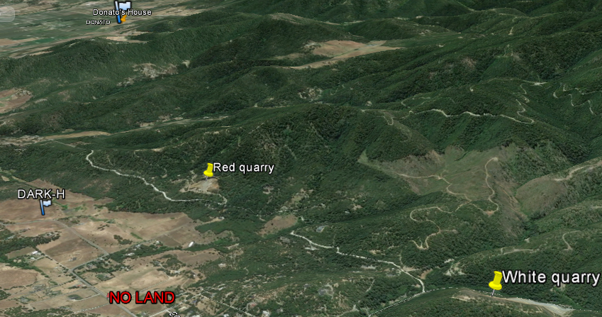
5. The tale of the two quarries White and Red. Remember this map from earlier?
We have successfully worked our way along the course and we are somewhere in the vicinity of the last three hotspots before Donato’s. See the map. Somewhere in here we need to climb to at least 5000 feet in order to make the last valley crossing to our goal. In front of you is the Dark Hollow Ridge. To the right of your course line is the white quarry. On the Dark Hollow ridge is a red quarry. Somewhere in here you need to get a climb. Usually you have to work at it. Patience is the name of the game. You really need to be close to 5000 feet to attempt the next jump because the intervening valley is pretty lacking in bailout lz’s and the wind is getting venturied into the higher terrain to the West. So, be patient. Troll. Pray. Don’t go until you get the height. Keep an LZ within reach during your trolling. Remember that there is one NO LAND ZONE that needs to be avoided even if it looks attractive.
6. Dark Hollow Landing Zone-the abode of the hopeless and forsaken and the non- patient. You bombed out.
Good job. You almost got there. Reflect on your performance. Weigh your decisions. What went well and what would you do differently next time? Did you run out of patience? Did you do anything questionable or sketchy as to your safety margins?
7. Leaving the Dark Hollow Ridge. You got your 5000 feet and you are ready to start your final push to Donato’s. AIRSPACE BECOMES THE KEY ISSUE FROM THIS POINT ON.
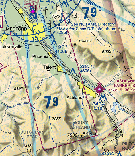
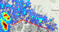
Notice the glide slopes on the bottom of this chart. Many of the airplanes are coming in on an instrument approach. The computer is descending according to pre-set altitudes. The pilots are not expecting anyone to be in their FAA designated flight path. They are descending according to the computer and are not necessarily looking out the windows to see if you are busting their airspace. In the near vicinity of Donato LZ the planes are descending and are below 7200 feet if on instrument approach. But, and it is a BIG BUT, the pilots can exert their freedom to declare VFR if the weather conditions allow it. Basically a VFR, Visual Flight Rules, flight can be lower than 7200. Numerous times near Donato’s, VFR flights will come through the corridor around 6000 ft.
The above picture is Google Earth at 28.51 miles above the surface. Note the numbers given by the respective waypoint. These are the altitudes that the airplane is to have at those locations. See also the above charts. Let’s zoom in closer. Let’s look at this same picture from 7200 MSL- this is close to altitude that planes transit this area along those glide slopes.
Donato’s house is on the left edge of this map and it shows his house in relationship to the MFR air descent corridor. The planes are coming through the corridor usually between 6-7000 feet. We have to stay below them or we run the real time risk of a mid-air or a near miss.
Have fun. Fly safe and responsibly.
Rick Ray
April, 2015