Last update:
3/2/2025
Dan Wells
Both the Herd Peak launch and LZ are on private land. A site intro and waiver are required.
The Basics
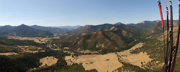
Herd Peak is an inland desert site located in the Shasta Valley. It has a long history of free flight and is known for its excellent summer glass-off conditions and XC potential. Both the launch and primary LZ are located on private land with permission granted for USHPA member pilots.
This site is known for strong thermal conditions in hot summers. Terrain areas have strong thermic potential. Pilots should have thermal and high-altitude launch signoff,
Herd Peak is a high desert remote area site that should only be flown by experienced thermal, xc pilots due to the level of situational awareness required regarding conditions both pre-flight and in-flight. This is neither a site nor an environment for novice pilots. Visitors should be accompanied by an experienced site pilot for briefing prior to flight.
Flight type(s): Thermal, XC, Glass-off
Season: Spring, summer, & fall
Pilot proficiency: USHPA P3/H3; P2/H2 with instructor or mentor sign off. Site intro required for all pilots.
Glider Restrictions: “Speed” or “mini” wings are not permitted.
Membership requirements: USHPA membership required; RVHPA membership recommended but not required.
Site Waiver: Required, usually available on launch. We recommend you download and print the waiver. Deposit signed waiver in box on launch.
Launch: 41.6166, – 122.229 (41°36’59” N, 122°13’44” W); Elev. : 5680 ft. (1732 m.); Dirt slope.
Wind direction(s) and speed for Herd Peak: 220 to 270 degrees. 2-14 mph for paragliders 10-20 mph for hangs. Ideal wind speed is 7 mph for paragldiers and 10 mph for hangs. Ideal wind direction is straight in.
Primary LZ (Sheep Rock Ranch): 41.5825, -122.2559 (41°34’57.02″ N, 122°15’21.10″ W); Elev. : 3495 ft. (1066 m.); GR: 6.5.
Radios & Communication: Local frequency is 151.505 MHz; cell service is good on launch and in primary LZ with most carriers.
Emergencies: Dial 911
Access: 2WD accessible via US highway and dirt US Forest Service roads.
Airspace & Air Traffic: No airspace restrictions in immediate vicinity; sail plane traffic is common in the area. Klamath Falls airport and military operation areas along XC routes have airspace restrictions and/or possible military air activity, including fighter jets.
Landing Restrictions: Landing out in the Lava Beds National Monument is prohibited without prior notification and permission of the National Park Service.
Weather hazards: Over development, cloud suck, strong desert conditions, dust devils, thermic LZ, high winds, density altitude.
Weather info: NWS Forecast for LZ, SoarCast, Grass Lake webcam
More info: ParaglidingEarth, Leonardo
RVHPA site contact: herdpeak@gmail.com; you may also post inquiries to the RVHPA Yahoo! Group.
Rules & Regulations
Flying Herd Peak

Welcome to the Herd Peak flying site. In the interest of preserving this remarkable flying site and to promote safe flying, we have prepared this guide to assist pilots in getting the most out of their time at Herd Peak. It is no substitute for a thorough site introduction from a knowledgeable pilot. As always, use your own judgment in determining whether it is safe or appropriate for you to fly the site under current conditions. If you are unsure, do not fly.
Conditions
Pilot Proficiency
Minimum USHPA skill rating for Herd Peak is H3/P3. A H2/P2 pilot may fly only with the approval of a USHPA instructor or mentor.
Launch & LZ
Cross Country
The Herd can be a launching point for XC flights, most of them heading north or northeast. Unless your route follows Highway 97, you’ll probably be flying over very remote and unforgiving forest, mountain, and lava terrain, much of it without easy (or any) road access or cell service. Detailed knowledge of flying routes, landing areas, and road access is essential to avoid long hikes out and/or an unintended night camping beneath your wing–this point cannot be overstated.
Pilots who regularly fly XC at Herd carry maps, a GPS, a SPOT or other satellite location tracker, extra water, food, spare batteries, a headlamp, and enough clothing in the event they spend the night out before being retrieved. A supplemental oxygen tank is a good idea in July, August, and September as cloudbase is often over 14,000 feet (4300 m) MSL.
Mobile phone coverage is limited to a narrow corridor along Hwy 97. Cross country flights and retrieval vehicles following cross pilots cannot assume that there will be mobile services away from the immediate vicinity of Hwy 97. Radios and satellite trackers, Spot, Inreach are crucial in being able to communicate for safety and retrieval. It is not uncommon, even with radios to lose line of sight communication with the pilot or chase vehicle. Xc pilots are encouraged to obtain their FCC ham license in order to be able to access local repeaters in the area. Chase/ retrieval vehicles will frequently need to stay within the mobile access corridor until the xc pilot has signalled a landing or help needed signal. That allows the chase/retrieval access to xcfind or xctrack mapping locations.
Landing in the Lava Beds National Monument is prohibited and pilots may be arrested and have gear confiscated. It is up to pilots to know the monument boundaries and ensure that they are able to fully clear the monument before attempting to fly over it. Do not land in crop fields anywhere along XC routes. Sailplanes and military aircraft are frequently encountered along XC routes and near The Whaleback.
In short, Herd is an advanced XC site and all pilots interested in flying XC here should carefully study maps, planned routes, and alternate routes. First time Whaleback cross country flights should be made with an experienced Whaleback XC pilot. This is not the place to try your first XC flight! All XC pilots and retrieve drivers should have the following paper maps: Klamath National Forest, Modoc Country, and Upper Klamath Basin. The DeLorme California Atlas & Gazetteer is very useful for retrieve but should not be relied upon exclusively. The BLM Lakeview District map is key for those really long flights northeastward.
Other
Getting to Herd Peak

Site History
Site Records
Hayden Glatte set the paraglider site record for distance on June 26, 2011 with an 87.8 mile (141.3 km) flight to Alturas, California.