Last update:
2/12/2025 Dan Wells

Special notes:
The nearest bailout, Hunter LZ is a working cattle ranch and should be treated as such. Please read LZ rules below. The Wells Land, Phil’s Farm and the LongSword Vineyard LZ is a viable LZ options in appropriate conditions.
Note LongSword LZ is only open when their tasting room is open. See LongSword rules for details
The launch at Woodrat Mountain is on public land however the bail out and nearby landing zones of Hunter and LongSword are on private land. By agreement with the landowners a USHPA and RVHPA club memberships are required to land on these fields
All instruction (solo or T-1/T-2/T-3) at Woodrat is conducted only with a local sponsorship, sign off, and an RVHPA membership. Contact Kevin Lee at kevin@thermaltracker.com (541-890-7142). See the Woodrat Mountain Instruction committee (WMIC) page for more details.
The Basics
Woodrat Mountain is a beautiful flying site for hang gliders and paragliders. With great weather, excellent XC opportunities, and regular evening glass-offs, it is the primary RVHPA flying site and has a 38+ year continuous history of free flying.
We would not be able to fly Woodrat without the generosity of local landowners that provide us with landing zones and parking areas. Our continued ability to fly here depends on all pilots adhering to the basic rules of the site and desires of these generous landowners.
Please help preserve this amazing site by reading this site guide, getting a site intro, and by following all rules at the mountain. Always check the RVHPA kiosk in the Bishop Creek Road parking area, , or the the club’s Telegram site for important updates before flying. Thank you and enjoy Woodrat!
Flight type(s): Thermal, XC, Glass-off
Season: Year-round; best in spring, summer, and early fall.
Pilot proficiency: Top Launch – USHPA P3/H3 required; P2/H2 allowed only with mentor or instructor sign-off. Mid Launch – H2/P2 minimum.
Glider Restrictions: “Speed” or “mini” wings are not permitted to use the Hunter LZ due to concerns on their glide ratio relative to a safe glide from launch to landing.
Membership requirements: Current RVHPA and USHPA memberships required to land at Hunter and LongSword Landing zones.
Top Launch: 42.2317, -123.004 (42°13’54” N, 123°0’14” W); Elevation : 3780 ft. (1162 m.); Gravel slope. Tiedowns for hang gliders are available along the south edge of the launch area.
Wind direction(s) and speed for North side Top launch: 330 to 050 degrees. 0-15 mph for paragliders 0-20 mph for hangs. Ideal wind speed is 7 mph for paragldiers and 10 mph for hangs. Ideal wind direction is straight in.
Wind direction(s) and speed for West side Top launch: 230 to 320 degrees. 0-15 mph for paragliders 0-20 mph for hangs. Ideal wind speed is 7 mph for paragldiers and 10 mph for hangs. Ideal wind direction is straight in.
Mid Launch: 42.2413, -123.0144 (42°14’28.61″N, 123° 0’51.82″W); Elevation : 2750 ft. (838 m.); grass slope
Wind direction(s) and speed: 210 degrees to 330 degrees. 0-15 mph for paragliders 0-20 mph for hangs Ideal wind speed is 7 mph for paragldiers and 10 mph for hangs. Ideal wind direction is straight in.
Hunter LZ (Hunter Ranch): 42.2471, -123.026 (42°14’49” N, 123°1’33” W); Elevation: 1650 ft. (503 m.); GR: 4.0 from both launches.
Phil’s Farm LZ (adjacent to LongSword LZ) 42.232683457, -123.0537803; Elevation 1450′ (442 m.) GR:5.9 from top launch.
Longsword LZ (Longsword Vineyard): 42.2328, -123.0553 (42°13’57.88″N, 123° 3’18.93″W); Elevation: 1460 ft. (445 m.); GR: 6.0 from top launch
Wells Land LZ 42.21754 -123.05055; Elevation 1470 ft. (450m) Glide ratio is similar to LongSword but the LZ is hidden from view at launch by Squires peak.
Radios & Communication: Local frequency is 158.400 MHz (151.955 reserved for instructional use only). When 158.400 is busy with other traffic 151.925 is often used as an alternate. Check with other pilots and make a radio check to be sure you are on the frequency being used.
Cell Service: Good on launches but variable in LZs depending on carrier.
Emergencies: dial 911
Access: 2WD accessible via paved and dirt roads.
Airspace & Air Traffic: No airspace restrictions in immediate vicinity. Private plane traffic is not uncommon. Medford airport has class D airspace with a large Class E surface extension to the east.
Weather hazards: Strong valley winds, turbulent inversions, convergence over launch & LZ, concealed S and E winds on launches.
Weather info: Ruch Forecast, Provolt Wx Station, Squaw Peak Wx Station, Longsword LZ Wx Station, Tallowbox Wx Station, RVHPA’s weather links
Waypoints & Google Earth Links: coming soon
More info: ParaglidingEarth, Leonardo
RVHPA Site Contact: see the RVHPA Google Group to ask a question or arrange a site intro.
Rules & Regulations
If it seems like we have a lot of rules at Woodrat, it is because we do—but they are all based on common sense and courtesy. These rules exist so that we can continue to fly at Woodrat and access the privately owned LZs that are essential to flying here. The magnificent sense of freedom we experience flying here comes at the small cost of following these rules. Please follow them and help us maintain the privilege of flying here.
Hunter LZ Rules (Please click the link)
LongSword LZ Rules (Please click the link)
Phil’s farm LZ Rules (Please click the link)
Wells land LZ Rules (Please click the link)
Bishop Creek Road Parking Area Rules
In an effort to reduce stress on the Hunter Ranch LZ and parking area, pilots often meet at the LongSword Vineyard LZ set car pools up to launch. The Bishop Creek Road parking area near the Hunter LZ is on private property adjacent to a residence and is located along a road that local residents use frequently. The landowner has asked us to adhere to these rules:
- Parking permitted for current RVHPA members only.
- Park “head in” to reduce risk of fire from car exhausts.
- No smoking & no alcohol.
- No dogs outside vehicles.
- No littering. Please pick up any litter you see.
- No loud music or noise.
- Do not block driveways or Bishop Creek Road at any time and do not set gear on or stand in the road.
- Walk on the shoulder of the road when going to/from the Hunter LZ.
- No overnight parking.
If the Hunter LZ/RVHPA parking area is full, do not park elsewhere along Bishop Creek Road. Instead, use one of these two options: 1) park in the designated pilot parking area at LongSword Vineyard (3/4 mile west of Ruch), or 2) head toward launch and at the first pullout along the BLM road (approximately 1 mile from Bishop Creek Road Parking area).
Rules of the Road when driving to launch
Of course, all regular state and federal laws apply to driving on the roads at Woodrat Mountain. Due to the number of driving accidents involving pilots and the number of neighbor complaints about pilots’ driving, please drive slowly, alertly, and courteously at all times! Expect oncoming traffic, pedestrians, dogs, goats, and equestrians at all times. Speed limit is 20 mph. Head-on collisions do happen on Woodrat Mountain! Drive safely!
Flying Woodrat Mountain
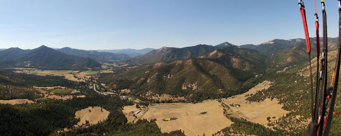
Woodrat Mountain has two launches, a primary LZ, and several other landing areas within a short distance.
Weather & Conditions
Woodrat can be a very reliable flying site and it is possible to fly most summer days. The best conditions have west, northwest, or north winds. The day or two after the passage of a cold front can be especially good. Spring flying conditions vary but include some of the best days of the year at Woodrat. Summer has consistent high pressure conditions. Early to mid fall is consistently good and has waning wind and lift conditions plus interruptions by the first major frontal systems of the cooler season. Winter days often offer sled rides or boaty flights around the mountain but occasionally give up a flights lasting an hour or more, sometimes over snowy forests.
As an inland thermic site, Woodrat’s flying conditions change during the course of any given day. Typically summer conditions are smooth and without much lift in the morning, lift builds mid-morning, light turbulence and thermals begin, and by noon or shortly later strong thermals and wind have developed. Summer and early fall evenings often have smooth, buoyant conditions and glass-offs are not uncommon but are essentially unpredictable. Wise pilots choose the time of day for conditions that match their skills and desires.
With the Pacific Ocean not too far to the west, marine weather often factors into Woodrat’s conditions. This is often expressed as a layer of stable marine-influenced air that caps the heated valley air below–an inversion. These inversions are very common on stable summer days and often occur between 4000 and 6000 feet MSL. Expect varying degrees of turbulence at these inversions and cooler air, possibly with different wind speed or direction above the inversion.
Weather Hazards
Woodrat is not safe to fly on strong south or east wind days due to large-scale rotor. The launches are shielded from south winds so study the forecast and consider using a helium balloon as a wind dummy if there is any chance of all but the very lightest east or south winds aloft.
Woodrat is often directly under a convergence zone of colliding Applegate & Rogue Valley winds. When this happens, winds on launch and in the LZ may alternate between N and W and/or the wind in the Hunter LZ may be opposite of winds on launch. Be especially cautious in these conditions.
Valley winds may increase rapidly on summer afternoons and during pre-frontal conditions, increasing thermic turbulence in the Hunter LZ.
See the weather page for links and more info.
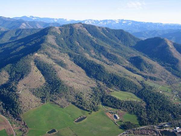
The Launches
Mid Launch
Mid Launch has two launch slopes, one facing southwest and the other facing northwest at about 2750 feet elevation. The southwest launch is a grassy slope with plenty of width and length. It is often used for launching into glass-offs, especially when the wind at Top Launch is too strong. The northwest launch requires laying out on the gravel road surface and performing a flat slope launch toward a steep drop off. The glide ratio from Mid Launch to the LZ at LongSword Vineyard is about 9:1!
Please park in the large, flat parking area above the launch slopes.
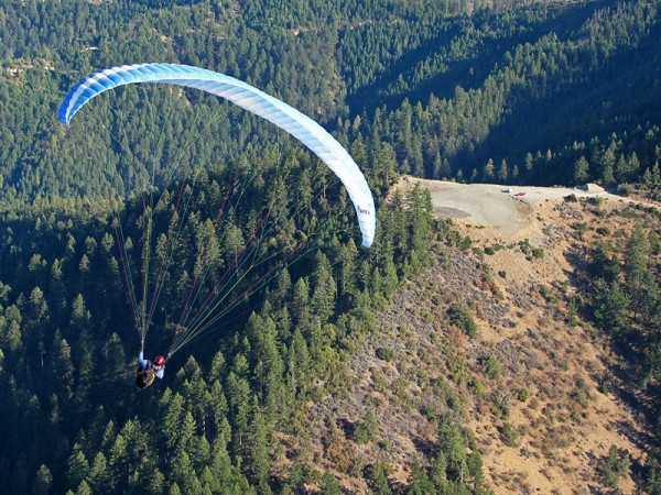
Top Launch
Top Launch has two launch slopes at 3780 feet elevation, one facing west and the other north. Both launches are covered in gravel. RVHPA maintains a windsock at the top of a tall fir tree between the two launches as well as numerous wind streamers. Tiedowns are available for hang gliders along the south side of the launch area. The glide ratio to the Hunter LZ is about 4:1, with either the LongSword Winery LZ being about a 6:1 glide.
The peak of Woodrat Mountain blocks southerly winds from directly hitting launch and may conceal evidence of rotor over the launch area. In fact, south winds may give the appearance of light cycles coming up either the west and/or north launches. Know the forecast winds aloft and be especially wary if there is any significant south component. Some pilots will check winds above launch by releasing a helium balloon on days with potential of south winds.
Landing Zones
Hunter LZ
The Hunter LZ is located at the northwestern base of Woodrat Mountain and has been the primary landing zone for over 30 years. The Hunter LZ has seen unprecedented stress due to overuse and a series of unfortunate incidents involving pilots and should be used with the utmost care and respect.
All pilots landing here must be current USHPA and RVHPA members.
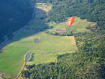
The Hunter LZ is the only LZ within a 4:1 glide of all launches at Woodrat Mountain, hence its strategic position as an LZ. This property is a working cattle ranch owned by the Hunter family and we need to be aware of the impact that our use of the LZ has on their cattle and livelihood. By all means, land at the Hunter LZ when you need to but, when safe to land elsewhere, please use other landing fields. The LongSword LZ, located just over one mile to the west, is now a frequently used LZ at Woodrat Mountain (see wind warnings).
RVHPA maintains several windsocks in the main field of the Hunter LZ. This may seem redundant but the various windsocks may give valuable information. For example, they may point toward each other when a large thermal is lifting off the center of the field. Or some may point one direction and the others opposite when a convergence line is centered over the LZ. Both these situations are common and require extra diligence for landing in the Hunter LZ. It is often better to fly to Longsword LZ when there are large thermals, convergence, or strong winds at the Hunter LZ. The Longsword Vineyard LZ is often smoother, more uniform, and safer in these conditions.
Please see the rules for using the Hunter LZ.
LongSword LZ (LongSword Vineyard):
Situated in the main part of the Applegate Valley just west of Ruch at an elevation of 1460 ft. ASL, the Longsword Vineyard LZ often has the smoothest conditions of any landing field near the mountain. This is often a wise choice of landing places in mid afternoon when other fields can become extraordinarily turbulent. All pilots landing here must be current USHPA and RVHPA club members.
The Longsword Vineyard LZ is the large flat field just south of the vineyard and east of the tasting room building and is about 10 acres in size. There are windsocks at the northeast corner of the landing field and at the fence line directly west of the center of the landing field.
There is a wine tasting structure and patio in the northwest corner of the landing field. Be aware of the rotor that develops in the lee of the building.
The glide ratio required from Top Launch to the Longsword LZ is about 6:1; from Mid Launch it is a 9:1 glide. Seriously consider whether you and your glider are capable of reaching the Longsword LZ before launching from Mid Launch (or even Top Launch). There is often a headwind between Woodrat and Longsword. A pronounced increase in headwind frequently occurs between Ruch and Longsword, specially in lower altitudes. Factor this in to your decision making as there are few safe places to bail out in the near vicinity of Ruch.
See all the rules for the LongSword LZ.
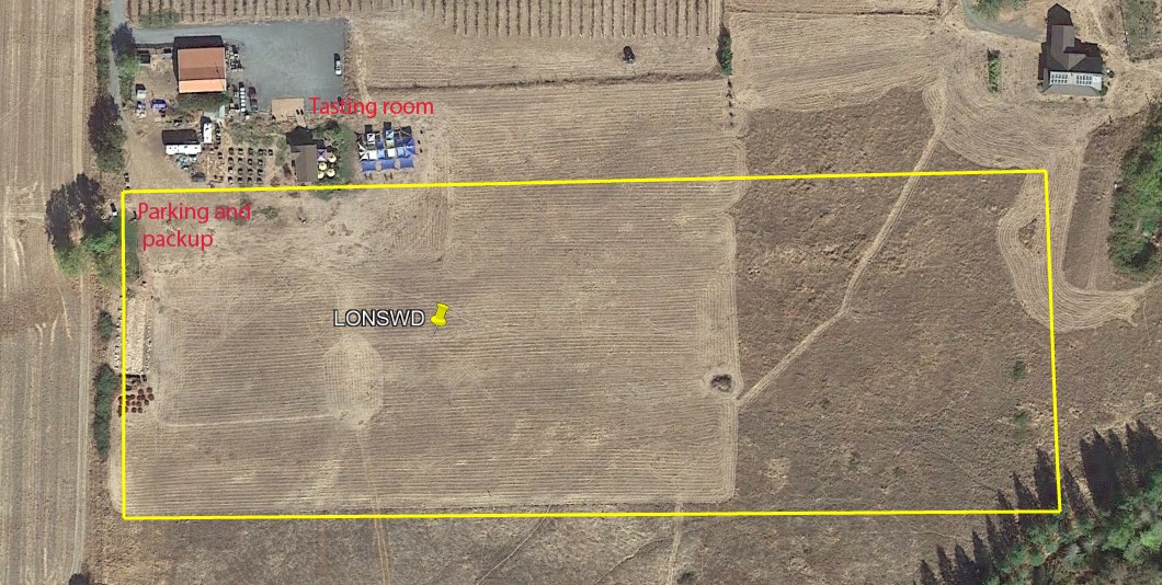
Wells Land LZ:
N42.21758 W123.05095 Elevation: 1470f ft.
Wells Land LZ is located .9 miles west of Squires peak at the mouth of the Upper Applegate Valley. It has approximately the same glide ratio as LongSword but is hidden from view on launch by Squires peak. Conditions there are generally less thermic than Hunters and more similar to LongSword. Just not as large. There are three landing areas between 180 to 200 yards in length with each surrounded by fences. There are two horses that may be present in landing zones 1 or 2. They are paraglider friendly and will not be spooked by landing pilots. LZ 3 is usable only if no hemp is being grown there.
Cautions:
In thermic conditions with light winds these landing zones require a higher level of skill than Hunter’s or LongSword. There is a slight downslope to the north and that coupled with thermals make landing without overshooting more challenging. Be sure to set up low enough before your final approach to give yourself some margin in case you get popped and end up landing longer than planned.
Also beware that the winds 1000 feet above the LZ can be much stronger than at the surface. Always make your initial approach well upwind of the landing zone to check your penetration. The windsocks are not the best indicators of the wind strength at altitude.
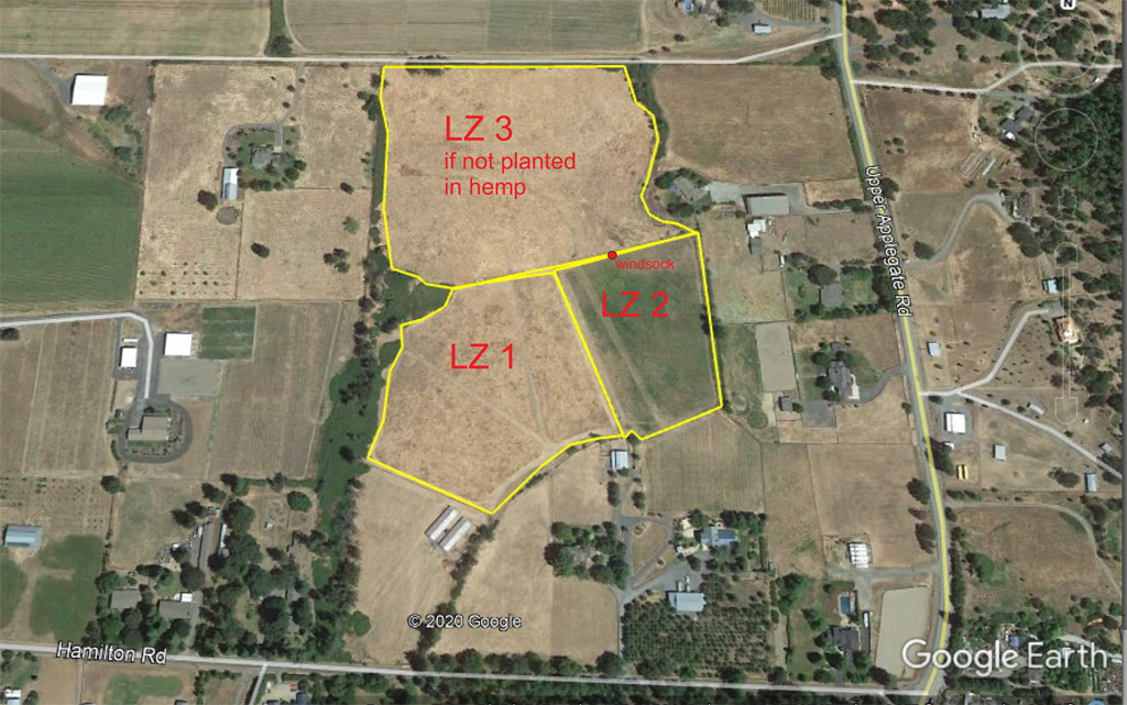
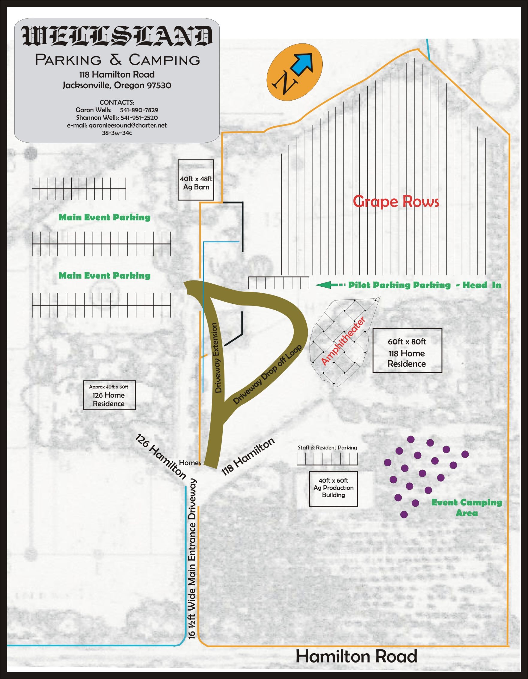
Wells Land’s street address is just off the Upper Applegate Rd at 118 Hamilton Road. Club pilots have permission to use the designated parking area for staging rides to launch from mid-morning to dusk.
Cross Country
Although most flights at Woodrat remain in the local area, the mountain has excellent cross country potential in every direction and XC flying is popular here. Common destinations for XC flights include Grants Pass (northwest), Applegate Lake (south), LZ Donato (east), Jacksonville, (north), and Applegate (west). There is Class E controlled airspace to north and east that affects XC flying in these directions; please consult a sectional map and know the location of controlled airspace for the MFR international airport.
Important Cross Country Land and No-land field Information
A Listing of landing zones with specific permission where pilots can land in the local flying area shown in green as well as closed or fields and/or we are requested NOT to land shown in red can be viewed at this link. Zoom in to see the specific location.
Also note that any field that has crops growing such as hay and especially CBD Hemp should be considered as no land fields prior to harvest when crops are growing.
Further details including obsticles and risk assessments for the most commonly used landing zones are listed in alphabetical order on a downloadable PDF file at this link.
There is also an OpenAir text file that pilots can load into their flight instruments that shows the fields mentioned above.
Social Hour
Flying at Woodrat is often a social experience as much as it is an aviation experience. There are pilots at the mountain nearly every good summer day. RVHPA members often hold impromptu barbeques at LongSword Winery or Mid Launch in the evening, spend time swimming in the river mid-day, or get together for lunch in Ruch or Jacksonville.
Getting to Woodrat Mountain
Woodrat Mountain is located eight miles south of Jacksonville and approximately 10 miles southwest of Medford, Oregon along Highway 238.
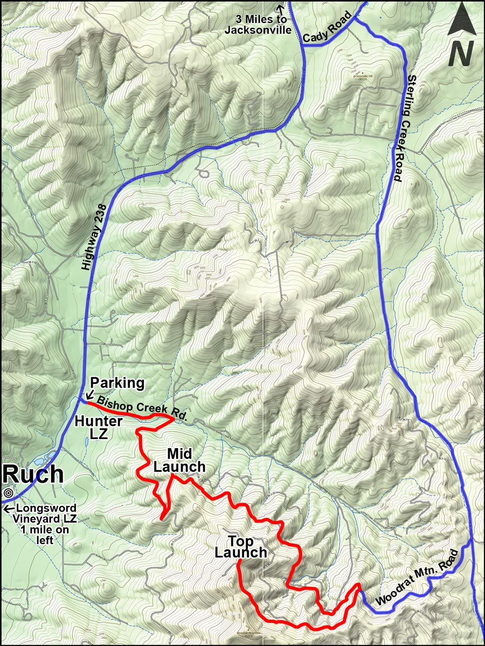
The Hunter LZ & Bishop Creek Road Parking Area
From I-5 follow the signs to Jacksonville, then continue on Highway 238 (California St.) for 6.5 miles toward Ruch. Turn left onto Bishop Creek Road (if you reach Ruch, you’ve gone one mile too far). Continue 500 feet on Bishop Creek Road and the parking area will be on your left. Please park only in the designated parking area. If it is full, you can continue up Bishop Creek Road 7/10 of a mile, turn right, and park at the large turnout on BLM land 1/2 mile beyond the 3rd cattle guard.
Phil’s farm LZ
From the Bishop Creek Road parking area: follow Highway 238 through the small town of Ruch, about ½ mile west of Bishop Creek Road. Turn at the driveway with the mailbox marked 8300 Hwy 238. There are two gates in the driveway. See Phil’s farm LZ rules for more details.
Longsword Vineyard LZ
From the Bishop Creek Road parking area: follow Highway 238 to the small town of Ruch, about ½ mile west of Bishop Creek Road. The Longsword Vineyard is on the left about ¾ mile west of Ruch. Please drive 5 mph on the gravel roads at the Longsword Vineyard and to help keep dust down by going slower when needed.
Wells Land LZ
From the Bishop Creek Road Parking area: Follow Hiway 238 through Ruch and turn left on the Upper Applegate Rd. Go approx. 1.7 mile to Hamilton Rd and turn right. Wells land entrance 118 Hamilton drive is 500 feet down the road on your right.
Mid Launch
From the Bishop Creek Road parking area, continue up Bishop Creek Road for 7/10 mile and, at the three-way intersection, turn hard right. Cross the cattle guard and continue uphill on the paved road for 1.5 miles. You will see the sign for Woodrat Mid Launch on your left, 2.3 miles from the LZ parking area. Please park in the upper parking area at Mid Launch and not next to the launch slopes.
Top Launch
There are two ways to reach Top Launch and they both take the same amount of time. Driving up the front side gives you access to Mid Launch along the way but entails more miles of dirt road driving. Going up the back side of Woodrat is paved except for the last two miles and is a good alternative for passenger cars. Expect oncoming traffic at all times on either of these routes and please drive slowly. Carpool to reduce traffic and minimize accident potential.
From the Front Side of Woodrat Mountain (more miles of dirt road)
From the main LZ parking area, continue up Bishop Creek Road for 7/10 mile and, at the three-way intersection, turn hard right. Cross the cattle guard and continue uphill on the paved road. Mid Launch will be on the left 2.3 miles from the LZ parking area. Continue to Top Launch on the paved road; before too long it will become a dirt road. Continue along this road (BLM Road 38-3-23.1), staying right at the intersection that is about 3 miles from the LZ parking area. Continue 1.5 more miles and you will reach top launch, 6.8 miles from the main LZ parking area.
From the Back Side of Woodrat Mountain (more miles of paved road)
From the Hunter LZ parking area, go back to Highway 238 and turn right (north). Continue on 238 for about four miles until reaching Cady Road at Jacksonville Hill Summit. Turn right onto Cady Road and continue 1/2 mile and turn left on Sterling Creek Road. Go 4.6 miles on Sterling Creek Road and, near the crest of a long hill, turn right onto Woodrat Mountain Road. Go 3/4 mile and, at the junction of dirt roads, turn left to stay on Woodrat Mountain Road (unsigned). Continue 1.5 miles to reach Top Launch.
Rides up to launch
There is no organized shuttle to launch. But there are generally enough pilots flying when the weather is good that you can get a ride. Pilots genrally meet at the LongSword Winery. Check Telegram site to see who is flying and when they are meeting. Drivers generally posts meetup times when they are driving. Please offer to chip in for fuel and wear and tear on the vehicle when getting a ride. It’s customary to offer $10 for a trip to Upper launch and $5 for a ride to Mid launch.
Site History
Please see the history page for photos and stories from the early days at Woodrat, beginning with the first flights in 1978.
Site Records
The current site record was set by Hayden Glatte on 7/10/2013. He launched Woodrat and landed 6 hours and 37 minutes later in Bly, Oregon, a straight line distance of 158.4 km.(98.4 miles). Check out the flight on Leonardo.
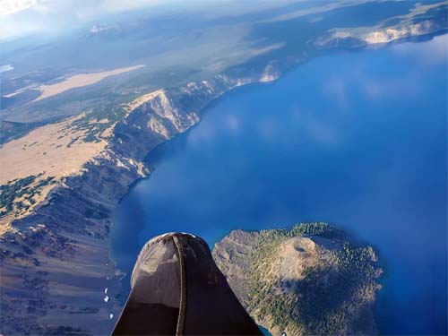
Although not a distance record, perhaps the most challenging and scenic flights was made by Destino Stellavem on 8/15/20. Launching from Woodrat, Destino flew for 6 hours and 15 minutes managing to fly over Mt. McGlaughlin, Crater Lake, and Mt. Thielsen before landing 135 kilometers (84 miles) from Woodrat near the intersection of Highway 97 and 138 nine miles south of Chemalt, Oregon. Details are on Leonardo.
Also worthy of note is a 164 km FAI triangle flight by Zion Susanno from Costa Rica on June 19, 2018. Details are on Leonardo. Previous triangles flown by local pilots had been less than half that distance.
Details of the record-setting hang glider flight are less clear. Pilot Mark Bennett made a flight to Hilt, California (approx. 25 miles / 40 km) around 1980. This may be the longest distance hang glider flight originating from Woodrat Mountain. Other long flights have gone past Grants Pass, Oregon. Please contact RVHPA if you have information on hang glider site records.
Woodrat Contacts
Please post on the club’s Telegram site to ask a question or arrange a site intro.