Understanding Rabe’s Ridge

An Article by Rick Ray

Rabies-view

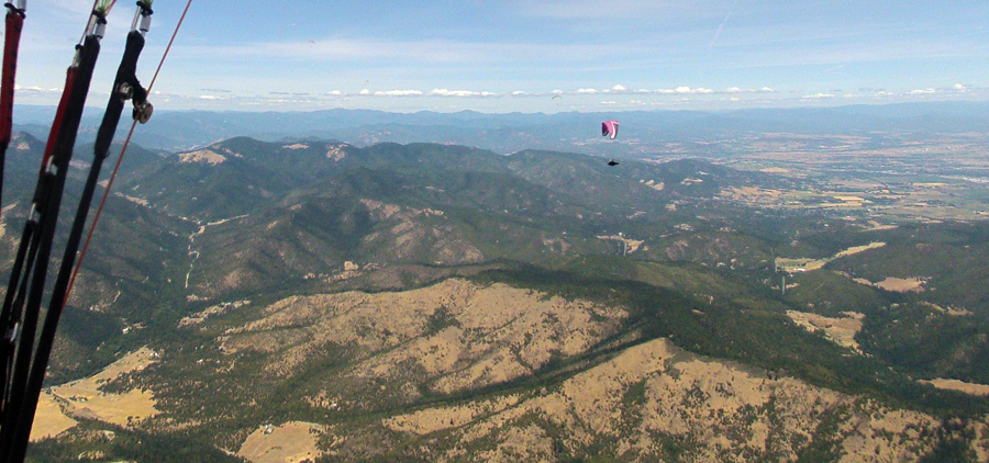
We start our discussion about the dynamics of Rabe’s Ridge with a toast. Hoist a brew in appreciation of Mike Rabe, the early Woodrat hang glider who pioneered much of the early exploration of the ridge above China Gulch. Flying from Woodrat in the early 1980’s, he spent so much time over there that the ridge was named for him. Thanks Mike for your inquisitive and bold exploration! We are all indebted to you.

As Yogi Berra said, “You can observe a lot just by looking.”

Rabies_1

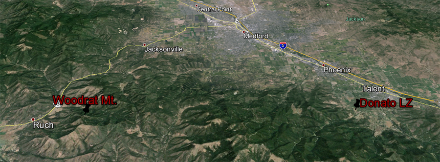
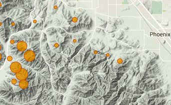
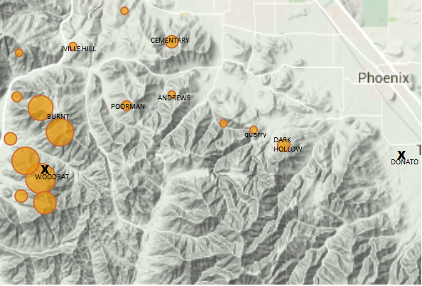
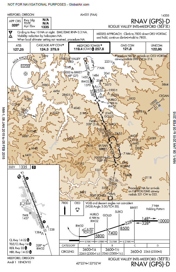
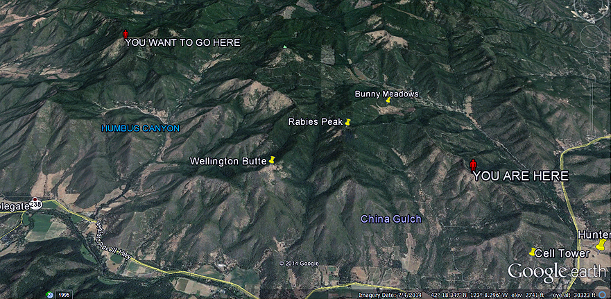
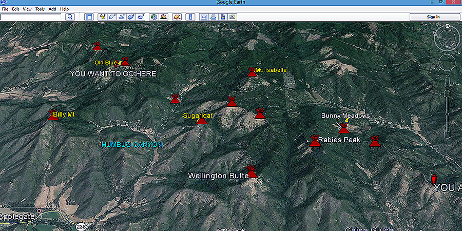
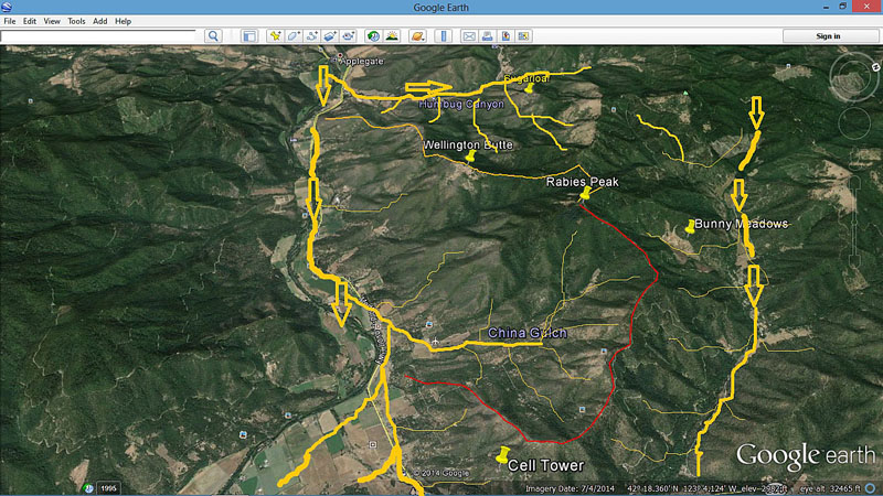
Rabe’s Ridge starts across the valley from Woodrat Mountain. I have outlined the ridge proper with a red line. Inside of that bounded area is China Gulch. I have also outlined the ridge just to the West of China Gulch with an orange line. The reason for that lies in the importance of that ridge for understanding some of the dynamics occurring along Rabe’s Ridge and within China Gulch.

TOPOGRAPHY:
The first element in trying to understand the dynamics of Rabe’s Ridge lies in its orientation. It is a catchment basin aligned towards the Southwest. It starts catching the full force of the sun’s heating very early in the morning and continues throughout the day. It is surrounded by higher terrain on three sides and therefore the trapped heat tends to stay within the gulch until it is either released in the form of a thermal or successfully works its way out of the gulch in the form of up slope flow.

VALLEY WINDS:
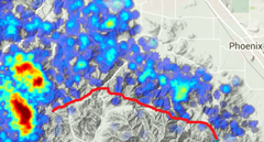
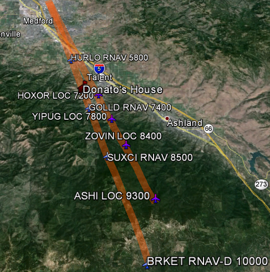
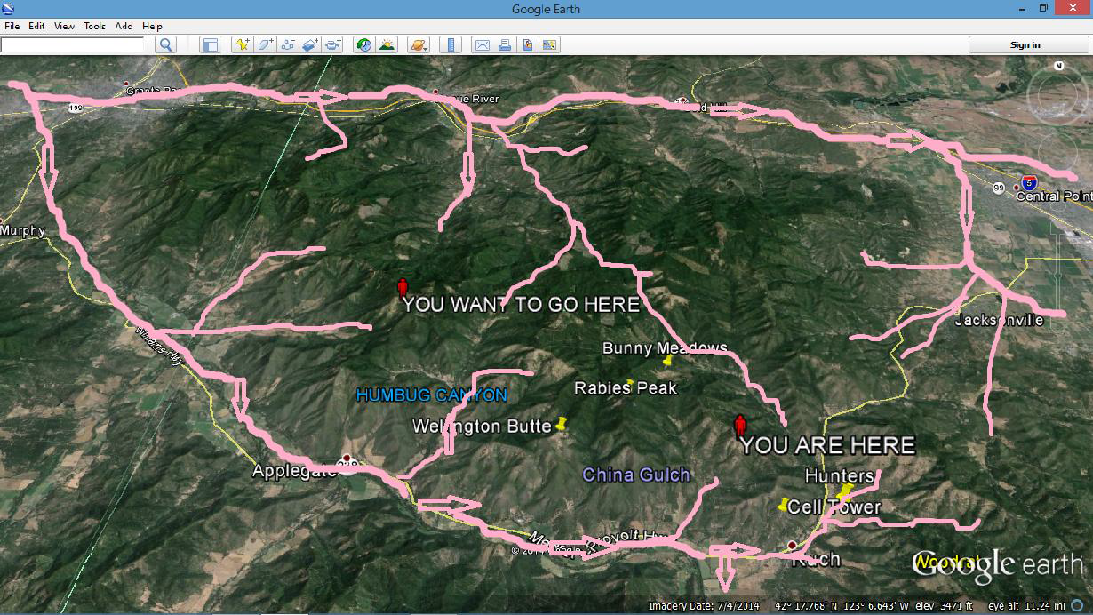
Consider the normal West up valley wind flow. Two sections from the MetEd site, Flow Interaction with Topography and Thermally-forced Circulation II: Mountain/Valley Breezes provide help in understanding how valley flow develops during the daytime. It is very important to realize that valley flow starts below ridge top levels but when fully developed, can extend up well above the valley sidewalls sometimes by a thousand feet or more feet. A simple illustration can be found in a loaf of bread. It starts out as a lump of dough that is below the pan height but as it bakes, it expands up and over the sides of the pan. Valley winds are similar. The important thing to realize is that valley winds can have a lower and upper level aspect to them. The lower aspect wind is below the valley rim and follows the contours of the valley as it winds its way towards higher terrain. The upper level valley winds, those above the sidewalls but below the larger regional winds, can skip over some of the bends and twists of the valley’s topography and then reunite with the lower level flows as it progresses towards the higher terrain. Above them are the larger scale winds. Here are a couple of maps to illustrate this.

Rabies2

The following picture is an attempt to show the lower level West up valley flow with the smaller upslope flows.

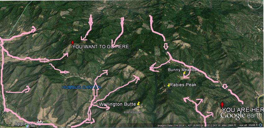
If we add in the upper level valley flow we get something like this:

Rabbies_3

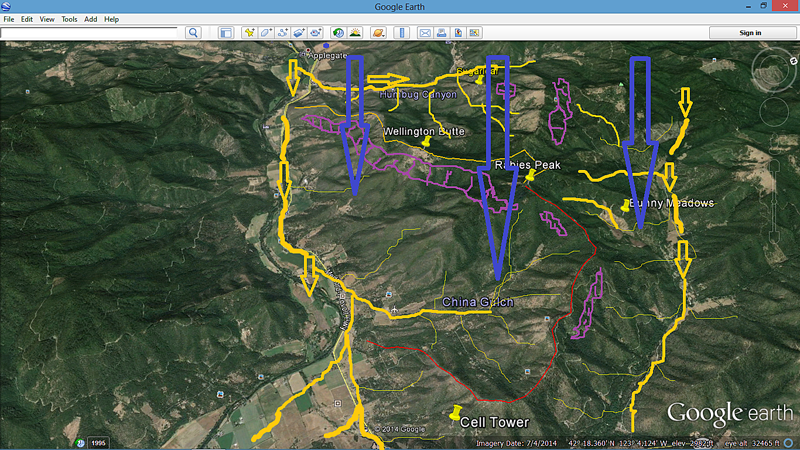
This is an attempt to show the complexity of a typical West up valley flow. The lower flow and the slope flow is marked in yellow. The upper valley flow is represented by the large blue arrows. The resulting rotor that occurs as the upper valley flow interacts with the terrain is the light purple sections.
The predominate up valley flow from the West is both compressing the air into the gulch in its lower level form and, more importantly, on a typical West flow day, is spilling over the higher ridge outlined in orange and flowing down and across the lower valley flow in the China Gulch areas as upper level valley flow. This has a number of important considerations when we try to understand what is happening when we fly Rabe’s Ridge.

INTERACTION OF TOPOGRAPHY AND VALLEY FLOW:

The interaction of up valley wind flow and topography turns the China Gulch area into an almost perfect thermal nursery. The importance of the split level valley wind flow, with the upper level flow being temporarily at an angle to the lower flow, is that for all intents and purposes, China Gulch is a lee side catchment basin. This has several important impacts on the relatively stagnant air mass within China Gulch. As air flows downhill there is an incremental increase in heating throughout the gulch. Additionally, the lee side of a ridge or mountain develops a micro-level low pressure system. The net effect of that low pressure is an increase in instability. This translates into a hotter air mass that is being encouraged to rise by the lower pressure differential.
Basically China Gulch becomes a super adiabatic thermal generator. Compared to other surrounding areas it releases thermals more frequently and of a greater relative strength than does more windswept areas or areas with more of a homogenous valley flow. We see the effects of these super adiabatic thermal releases almost all the time while flying Rabe’s Ridge. We usually climb 500 to 1000 feet higher along the ridge than we do elsewhere. This is a direct result of these more potent thermals emerging out of China Gulch.

FLYING RABE’S RIDGE ON A TYPICAL LIGHT WEST VALLEY FLOW DAY:

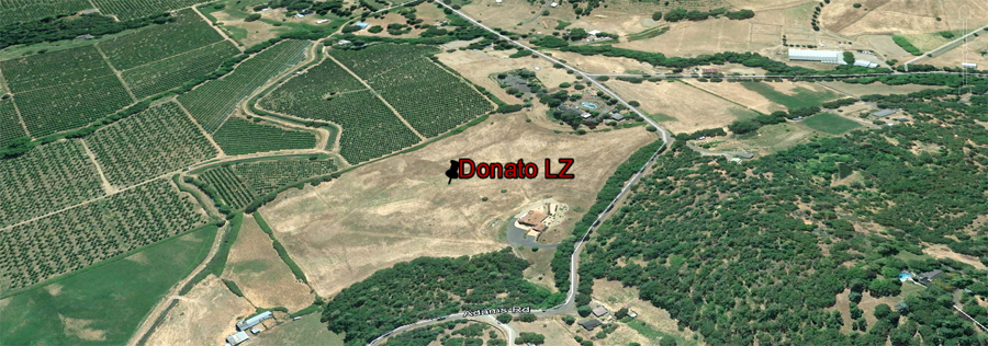
1. There are NO SAFE landing zones inside of China Gulch! You have to either climb out or leave yourself enough height to return to Hunters or Longswords. There have been a number of broken bones and torn up gliders that have resulted from ignoring this.

2. Don’t get below the ridges! See #1. If you get below the ridges, you run a good chance of encountering the upper level valley flow as it interacts with the terrain. Alternatively, you will be possibly exposing yourself to a super adiabatic thermal close to the ground. It is okay to scream if you ignore this advice and encounter one.

Rabies_4

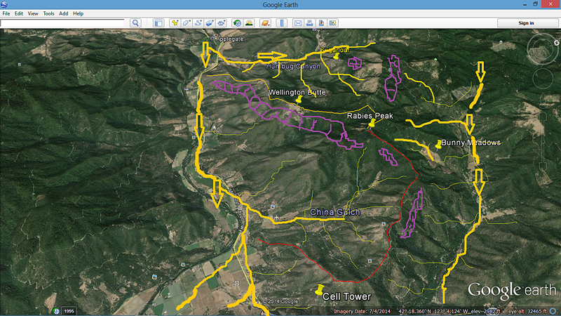
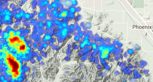
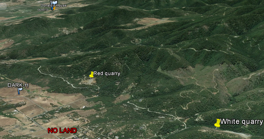
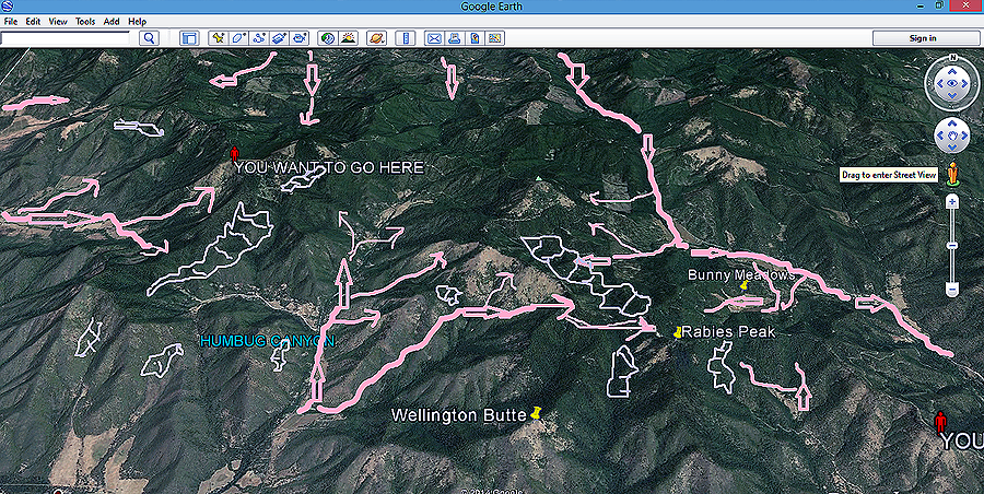
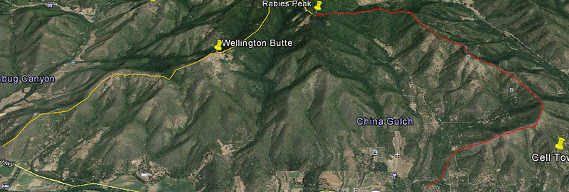
This picture shows most of the known rotor areas that develop on a typical West up valley flow day. The size and the intensity of the rotor areas are directly tied to wind speed. The stronger the velocity, the more intense the rotor is going to be. Basically, avoid flying below ridge level while in China Gulch especially in the Wellington Butte to Rabe’s Peak area and in the Rabe’s Peak to Sugar Loaf area.

3. There is often an amazing amount of bubbly lift and its associated turbulence drifting along Rabe’s Ridge as the two levels of valley flow merge. It often feels like weaker bits and pieces of wandering thermals between the pronounced thermals. I often think of it as the Rabe’s Ridge flak zone. Like some old World War 2 bomber flying through a flak field, my glider shudders and surges as I go questing up towards Rabe’s Peak in search of a coherent climb. Then, boom, there‘s the mothership! My point is, make sure that you are really in a developed thermal before you start turning. Additionally, it is not uncommon to start climbing in a upslope flow thermal along Rabe’s Ridge towards the West and then enter into the upper level valley wind and find yourself being pushed towards the East. Frequently, you have to stair step your way towards Rabe’s Peak. You push forward into the thermal and then as it climbs up into the upper level valley winds, you drift back towards Woodrat or Burnt and then push forwards towards Rabe’s Peak again and catch another thermal further up the ridge and repeat.

4. It is possible to get too much of a good thing. Sometimes the super adiabatic thermals can just be bigger than I am willing to eat or try to drag home. Some days I just need to cut and run. It is like the old Kenny Rogers song “Know when to hold them, know when to fold them, know when to run away”. Fly within your comfort zone and realistically know your own limitations.

5. A fun part of flying Rabe’s Ridge is the fact that the upper monsoonal flow over the whole region during the summer is from the South. It makes it possible for us to frequently climb through both valley layers while thermalling on Rabe’s and climb up into the South flow. Sometimes this makes it possible to fly to Grant’s Pass with a tailwind as long as we are above the valley winds, then fly back to Woodrat at a lower level with a tailwind using the upper level valley flow. Tailwinds in both directions but at different altitudes. Sweet! For non XC pilots, the ability to sometimes climb to 10,000 feet on a good day is its own reward.

6. Rabe’s Ridge on a North wind influenced day is for experienced pilots only. As a North wind develops and makes its influence felt, the lift coming out of China Gulch is driven off of the ridge as the North begins to exert itself. A Northerly wind creates a nasty sheer as the lower level up valley flow clashes with the North. As it swings more, past 330 degrees, the sheer gets very pronounced. In the 2014 Rat Race, we had the most ever reserve tosses within a period of days. A weather comparison looking at Medford airport winds for the period 2008-2014 revealed that one of the primary differences between 2014 and earlier years laid in the high number of days with the wind flow exceeding 320 degrees. Rabe’s Ridge on Northerly days yields significant turbulence and isn’t that enjoyable.

Additional reading:

C.D.Whiteman. Mountain Meteorology: Fundamentals and Applications.
Leeside throughing download at: http://www.atmos.albany.edu/student/dthompso/ATM504%20Presentation.ppt
Also http://arxiv.org/ftp/arxiv/papers/1311/1311.1860.pdf

Rick Ray January 31, 2015

Understanding Burnt Ridge

An Article by Rick Ray

Burntt_banner

Once upon a time, there were three paragliding pilots named Lucky, Skilled, and Judgment. Much like the story of the three little pigs, it was the last named of the three pigs that kept them all from finally getting devoured by the Bad Wolf. In the real world, it is educated judgment that will go a long way towards insuring that you have a safe flying career.It will help you chose when, where and how to fly.

The following is a test run for a discussion about Flying at Woodrat and How and Why it seems to work as it does. Some of what follows are educated guesses on mine and others part.  I hope to help our newer pilots and relocated pilots gain an understanding of why our airmass is as it is. For newer pilots to hear talk about House Thermals, Convergence Lines, Rotor Zones, and the Wall of Wind is intimidating and makes what they are getting ready to launch into mysterious and slightly spooky. Hopefully, this discussion will help you fly with more confidence and insight.

I want to introduce an awesome, free, weather resource that will professional level discussions and illustrations of what is happening around Woodrat.

https://www.meted.ucar.edu/index.php

I would strongly encourage you to create your own account. After you have created your account click on the Education and Training button and then, after browsing around, click on the Mountain Meteorology button.
From a meteorological viewpoint, Burnt Ridge is one of the more important features influencing the flying in the immediate vicinity of Woodrat.

https://www.meted.ucar.edu/training_module.php?id=57#.VKLbJl4CcA.

This module on “flow interaction with topography” found in the Mountain Meteorology section illustrates how and why Burnt plays such an important role in our local flying. As the valley flow comes by Woodrat, we can see how Burnt Ridge creates a compression zone that effectively slows the wind down in the immediate area of Woodrat Mountain. We can see how and why that the outer edge of that compression area (towards Longsword) causes a deflection of some of the incoming valley wind causing an acceleration or barrier jet to form. This is our so-called Wall of Wind. Understand when they say jet, that they are only talking about a relative escalation of the ambient wind speed. Simplistically pu, wind ,like water, seeks the path of least resistance. Instead of pushing against the gradient caused by Burnt Ridge, and rather than having to push through the existing compressed airmass or climb up and over it, some of the air takes the path of least resistance and hurries off towards the lake.

Burnt Ridge is also one of the causal factors in why we have such frequent convergence zones in the immediate vicinity of Woodrat. Air is never a static state. It pulses and surges and ebbs.This undulation is caused in part by the Applegate valley flow pressure out near Longsword. As the valley flow surges or ebbs, it causes the slowed down airmass from the vicinity of school to Burnt Ridge to flex by either tightening up or relaxing. Think just for a moment of a big crowd of people in a confined area. Add one more, they squish together. Take one away and everyone relaxes a little bit. Same thing at Woodrat. Pressure against a compression zone causes ripples to run through the compressed airmass. Another cause of convergence caused by Burnt Ridge is the downward flowing air in Forrest Creek attempting to squeeze into the compressed air in front of Burnt.

Burnt Ridge plays a very important role in the quality of our flying experience at Woodrat. Hopefully this brief look at Flow interaction With Topography will stimulate a good discussion. If we can learn and visualize what is going on, we will make safer flying decisions over time.

Rick Ray

December 30, 2014

Flying to Donato’s

An Article by Rick Ray

Donato_banner


Flying around Woodrat Mountain takes many forms. From the first exhilarating flights of the new student, to magical glass offs, to the first venturing afield out to LongSword winery, there are many rites of passage that we move through as we develop as a pilot. We remember the wonder of that first thermal flight as suddenly we started going up. We were catching a glimpse of the invisible power around us as the atmosphere moves and flexes. Through trial and error, mentoring and study, we soon became proficient at finding a second and then a third thermal. Our flights started lasting longer and longer. We started getting higher and higher on the better days. Then, under the tutelage of a mentor, we made the trip out to LongSword winery. As our skills advanced and we could bumble about the valley on our own, seemingly at will, our world shrank, until the Ruch area wasn’t big enough to hold us. We wanted to explore.

The topic here is about flying from Woodrat to Donato’s house in Talent, a distance of about 10 miles. It is not a long flight in terms of distance but it is a significant flight in terms of the skills and judgment required to safely accomplish. Safety considerations, airspace realities, landing zone accessibility, thermal and lift locations are going to dictate how we responsibly navigate those 10 miles.
Donato_1

On the left you can see Woodrat. On the right, we see Donato’s house. That is our goal.  So how do we get to Donato’s?
For this discussion, we are going to fly from Burnt Ridge on a TYPICAL WEST VALLEY FLOW DAY at Woodrat. North flow days around the Woodrat Mountain area yield a different dynamic and that is not covered in this material.
The short 10 mile flight to Donato’s is not a magic carpet ride and there are no guarantees that you will pull it off if you follow this guide. However, we have had hundreds and hundreds of pilots in competitions and free flyers that have made it to Donato’s over the years. A compilation of the track logs of many of these flights can be found on Michael von Kanel’s website.


Here is the raw data from his site with all the thermal lift locations marked in blue. These are locations where people have found lift. Don’t get excited yet!

Donato_2


If we then use the toolbar and uncheck ‘show thermals’ and check ‘show hotspots’ then we get a map that looks like this.

Donato_3and_10

If we then superimpose the Woodrat waypoint list then we get a map  that looks like this.  Note that for the most part, the hotspots and the waypoints coincide.

Donato_4

.

Now we are getting somewhere. We have some of the elements that we need to create a plan whereby we are going to fly to Donato’s. But, first we need to add another very important detail: Medford AIRSPACE. Medford is a Class E airspace and there are APPROACH CORRIDORS IN THE NEAR VICINITY TO DONATO’S.

Donato_5


Note that the approach corridor is in near proximity to Donato’s. If we take the sectional waypoints and put them on Google, then it looks like this.

Donato_6


NOTICE SEVERAL CRITICALLY IMPORTANT POINTS.

1.The descent corridor is in close proximity to Donato’s house. The approach corridor comes down from the vicinity of Mt. Ashland and Wagner Butte and follows the Wagner creek drainage towards Talent and Medford. The white line shown is a generalized glide line. The important point is that descending aircraft come through the drainage, dropping down from the high ground in the West and traversing the area in the near vicinity of Donato’s house.

2. The elevation at Donato’s house is approximately 2000MSL. The airplanes near his house are descending, crossing from West to East, at approximately 7200 MSL.

3. The further you get out into the main Medford valley towards I-5 then the lower the planes are.


WHAT ARE THE IMPLICATIONS OF THE AIRSPACE AND HOW DOES IT IMPACT OUR TRIP TO DONATO’S?

At Woodrat, we are near the edge of the Medford airspace. Woodrat is not in the keyway extension.

Donato_7and_13

We are flying to the very edge of an active descent corridor. WE MUST FLY RESPONSIBLE. We don’t break airspace by flying towards Medford. We don’t break airspace by flying out towards the I-5 corridor. We don’t break airspace by encroaching into the airplane descent altitudes near Donato’s. We land at Donato’s located immediately this side of the corridor. We make sure that that landing approach is less than 5000 MSL and is made from the Southwest edge of the Anderson Creek/Wagner Creek drainage.


HAVING ASSEMBLED THE PIECES, LET’S FLY TO DONATO’S FROM WOODRAT VIA BURNT RIDGE.

Burnt Ridge is the interface zone between the Applegate Valley in which Woodrat is located and the Rogue River Valley in which Medford and Donato’s is located. On a typical WEST VALLEY FLOW day at Woodrat, it is a convergence zone . Winds are coming up from the Ruch side from the West and from the Jacksonville /Medford side from the North. The convergence zone that results from these clashing windflows often produces incredible climbs. Sometimes the climbs can be turbulent as the thermals push up through and around the competing windflows. Remember that convergences always have a windward and a leeside and as the altitude changes these can reverse places with an accompanying horizontal wind sheer. The thermals at Burnt tend to slide up the interface zone while being deflected towards the weaker side of the convergence. For example, if the Jacksonville push is stronger, the thermal inclination during the climb tends toward Ruch and visa versa.

1. BEFORE YOU LAUNCH BE FAMILIAR WITH THE NO LAND AREAS! There are three located along the route towards Donato’s. It is Your responsibility to know where these are and to avoid them otherwise you put our flying site at risk by creating ill will and the possibility of bad reports.  See RVHPA  LZ information at http://bit.ly/rvhpa-lz
Donato_8

2. Look at the hotspot map from earlier. This will give you and idea of where the more consistent lift has been found. You will want to string these together like the beads on a necklace. However, there often is a surprising amount of convergence lift to be found on the way to Donato’s. I think that we see this in the numerous lift sources on one of the earlier maps.

3. When to start? When do I leave the Woodrat area to go towards Burnt? The higher the better. You do not want to get to Burnt below ridge top! If the Jacksonville flow is strong and you arrive below ridge height, you would be inside the rotor zone and close to the ground. A bad place to find oneself! Get to Burnt above ridge height! The higher the better. Lower class gliders should have at least 5000 feet at Woodrat before attempting the crossing to Burnt. Higher is good.
I usually aim for the Burnt waypoint and then troll back and forth along Burnt ridge between Hwy 238 and the waypoint until I hit lift. That is, unless Hayden is there. Then, I just follow Hayden. Don’t leave Burnt to go on towards Donato’s below 5500. It very seldom pays off. Patience is the name of the game. Wait until you get the great climb. The higher the better. It gives you more options later in the course. Leaving Burnt, I usually head towards Portman’s or Cemetery waypoints because they also happen to be hotspots.

4.CAUTION. Notice that even on the general thermal map that very little lift is found in the fingers and spines as you move towards Donato’s. I have marked them with a red line. They are a very attractive trap. There are no landing zones. It is a long glide out to safety against a headwind. There have been a number of serious injuries that have occurred with pilots getting trapped in there. STAY TOWARDS THE MAIN VALLEY.

Donato_9

5. The tale of the two quarries White and Red. Remember this map from earlier?

Donato_4

We have successfully worked our way along the course and we are somewhere in the vicinity of the last three hotspots before Donato’s. See the map. Somewhere in here we need to climb to at least 5000 feet in order to make the last valley crossing to our goal. In front of you is the Dark Hollow Ridge. To the right of your course line is the white quarry. On the Dark Hollow ridge is a red quarry. Somewhere in here you need to get a climb. Usually you have to work at it. Patience is the name of the game. You really need to be close to 5000 feet to attempt the next jump because the intervening valley is pretty lacking in bailout lz’s and the wind is getting venturied into the higher terrain to the West. So, be patient. Troll. Pray. Don’t go until you get the height. Keep an LZ within reach during your trolling. Remember that there is one NO LAND ZONE that needs to be avoided even if it looks attractive.

Donato_11

6. Dark Hollow Landing Zone-the abode of the hopeless and forsaken and the non- patient. You bombed out.

Donato_12A

Good job. You almost got there. Reflect on your performance. Weigh your decisions. What went well and what would you do differently next time? Did you run out of patience? Did you do anything questionable or sketchy as to your safety margins?

7. Leaving the Dark Hollow Ridge. You got your 5000 feet and you are ready to start your final push to Donato’s. AIRSPACE BECOMES THE KEY ISSUE FROM THIS POINT ON.

Donato_7and_13

Donato_14

Notice the glide slopes on the bottom of this chart.  Many of the airplanes are coming in on an instrument approach. The computer is descending according to pre-set altitudes. The pilots are not expecting anyone to be in their FAA designated flight path. They are descending according to the computer and are not necessarily looking out the windows to see if you are busting their airspace. In the near vicinity of Donato LZ the planes are descending and are below 7200 feet if on instrument approach. But, and it is a BIG BUT, the pilots can exert their freedom to declare VFR if the weather conditions allow it. Basically a VFR, Visual Flight Rules, flight can be lower than 7200. Numerous times near Donato’s, VFR flights will come through the corridor around 6000 ft.

Donato_15

The above picture is Google Earth at 28.51 miles above the surface. Note the numbers given by the respective waypoint. These are the altitudes that the airplane is to have at those locations. See also the above charts. Let’s zoom in closer. Let’s look at this same picture from 7200 MSL- this is close to altitude that planes transit this area along those glide slopes.

Donato_16

Donato’s house is on the left edge of this map and it shows his house in relationship to the MFR air descent corridor. The planes are coming through the corridor usually between 6-7000 feet. We have to stay below them or we run the real time risk of a mid-air or a near miss.

Have fun.   Fly safe and responsibly.

Rick Ray

April, 2015


Dealing with Humbug

An Article by Rick Ray

Humbug_banner


There you are, our young P2 or low experienced P3, happily flying around Woodrat. You are feeling all studly and excited about your flying prowess, when THE VOICE comes over the radio “ YOU are flying in a bad spot and YOU need to get out of there-now!”
“Oh, okay” ,some say.
“Dammit” say another. “Not again. Leave me alone”.
The point lying behind this well-intentioned advice is two-fold. First, the more experienced pilot is trying to keep you out of trouble. Secondly, they are trying to help you develop your own judgment skills so that you don’t get into a bad place in the first place, or, having gotten into such a place, that you recognize it as such and extract yourself posthaste. Hopefully, the more experienced pilot will seek you out after landing and help you understand why THAT PLACE was a bad place.
Until you develop this skill set, you really shouldn’t be attempting to fly in the upper regions of Rabies Ridge. You need to have the recognition software hardwired into your flying that is able to recognize and avoid “bad areas”. Flying towards Donato’s or attempting to navigate upper Rabies Ridge and tackling the Humbug crossing requires good judgment skills. Both are totally achievable goals and the flights have been successfully and safely made by literally hundreds of pilots through the years. Unfortunately, however, there have been numerous instances of pilots tackling those flights and ending up in trouble, reserve tosses, injuries, or torn up gliders. For those pilots, their recognition software was non-existent or temporarily on the blink- they didn’t realize fast enough that they had gotten themselves in a bad spot and failed to leave it soon enough.
With good judgment skills both flights are totally doable.
Next time you hear THE VOICE on the radio, instead of being resentful, hear it as an encouragement and a challenge to fly further and to fly safer by learning to recognize what a bad area looks like.


NAVIGATING UPPPER RABIES AND DEALING WITH HUMBUG.

Humbug-getting-there

Whether it is flying at Woodrat or any place else, the basic question is “What are the winds doing?”

LARGE SCALE AREA WIND MAP

Region_map_Main_wind_flow


On a typical WEST up valley flow day, the winds flow out of the Grants Pass area and make their way up the two major drainages, the Applegate and the Rogue, as they flow towards the high ground.


ZOOMING IN ON THE HUMBUG AND RABIES RIDGE AREA

Humbug_larger_wind_flow

Basically, we have an area of competing windflows. Because of the drainage systems coming off of the Applegate and Rogue, the valley flow coming out of the Grants Pass area are frequently trying to merge. The coming together of these various up-slope flows results in this area being known for its convergences and its “uh… Texture.” The area is also known for the relative strong strength of its thermals especially in the area of Rabies Peak and Old Blue.
The most important point to have firmly fixed in your mind is that there is a lot of things going on with the windflows in the upper Rabies Ridge and Humbug canyon areas. An appreciation of these dynamics can make us more successful in flying across the area. The knowledge of how things are working can help increase our safety by helping us recognize areas that we should be cautious in or avoid altogether.


ROTOR AREAS UPPER RABIES AND HUMBUG MAP

Humbug_rotors2

Here is a closer look at the windflow with the known potential rotor areas represented by the light blue. Unfortunately, I have blundered into most of these or have watched wide eyed as others demonstrated exactly why one should stay out of those spots. It is a sobering thing to listen to grow men and women whimper! TO SAFELY FLY IN AND THROUGH THIS AREA REQUIRES GOOD JUDGMENT THAT COMES THROUGH EXPERIENCE. You need to be able to recognize quickly exactly what is happening with your immediate windflow and then accurately assess the impacts of that specific windflow as far as your near topography goes. Three questions should be churning through your brain: WHAT IS THE WIND DOING? AM I IN A CLEAN WINDFLOW? DO I HAVE SUFFICIENT GROUND CLEARANCE? If those questions are not floating around in the back of your mind then you are in the wrong area for this point in your flying career.


THERMAL MAP OF UPPER RABIES AND HUMBUG

Humbug-thermals2


Lest you think that this is all gloom and doom, the positive side is that the Upper Rabies Peak and Humbug area usually abounds with thermals because of the wind interactions. Here are the locations of some of them. Understand that these are general areas. The thermals are not tied to a tree and just waiting for you to get to Point X. But, these are great fishing spots and plenty of thermals have been caught here in the past. Bear in mind, that you might hook into a thermal that might be a little spicier than you like. The specific interface thermals near Rabies Peak, Bunny Meadows, Sugar Loaf, Old Blue will frequently be on the large side. My suspicions are that we are getting a merged thermal release coming out of the respective windflow zones? Kind of like a super release? Anyway, for whatever reason, the thermals coming off of these regions will occasionally be in the 1800 fpm range. The word “Yarded” comes into play at that point. As in “I was ripped or Yarded into the sky”. (while desperately seeking my mom!) But, you never know until you get there.


DEALING WITH HUMBUG DO’s and DON’Ts

1. You can never be too high to cross Humbug! It is approximately 4 miles from Rabies Peak to Old Blue. It is approximately 2 miles from Sugarloaf to Old Blue. On any typical day you will be gliding against the valley flow spilling through the Slagle gap located between Old Blue and Billy Mt. I have been at 7500 feet and not made it. Conversely, I have sailed across with ease from 5000 feet. It is VERY wind strength dependent. In lighter valley flow days it is easier to cross.
2. DO NOT COME INTO OLD BLUE BELOW RIDGE HEIGHT! Your momma ain’t going to help you and you stand a good cause of getting your ass kicked by the rotor produced either by the winds flowing through the Slagle Gap or by the downstream thermal turbulence caused by a huge Old Blue thermal release or
by a combination of the above. In either case, DON’T CONTINUE TO PUSH IN IF YOU GET BELOW RIDGE HEIGHT.
3. DO NOT GET WIND SHADOWED AT BILLY MOUNTAIN. The wind is coming from the Grants Pass area. Make sure that you sure above the top and be careful on all the ridges and protrusions as the local winds can sharply vary. If you bomb the crossing to Old Blue, DO NOT try to sneak immediately behind Billy on the way to the mouth of Humbug. If you bomb, try instead to follow the Humbug side of the Wellington Butte ridge. It is frequently possible to get back into the game and find a thermal because the upper level valley flow is pushing lift over to that area as it spills over into the China Gulch area.
4. Don’t let yourself get below the grassy slope between Rabies Peak and Sugarloaf. There is a nasty wind blocked rotor that forms behind Sugarloaf. And the lift getting pushed over the corner towards Rabies Peak is frequently quite textured. The glide out to a safe landing zone is really puckering.
5. There are some bailout landing areas in the lower Humbug canyon. Just remember that Humbug has an up canyon flow with a crossing upper flow from the West. Don’t get wind shadowed by Billy. There is a largish field that lies just across Hwy 238 at the mouth of the canyon. You really do not want to land in Bunny Meadows as it is a significant thermal release area. If you are in the vicinity of Rabies Peak, your bailouts are Hunters or Longswords. Remember that you want to be at least 200 feet over Wellinton before running towards Longswords. It puts you above the resident rotor that lies behind Wellington on the China Gulch side.
6. This is a fun and challenging area to fly. I always look at my flights into the upper Rabies Ridge and Humbug areas as being special. It’s like being given a box of Crackerjacks- you never know what the prize is going to be. I might be able to continue on to Grants Pass. I might tuck my tail and run. You just never know.

Safely flying Humbug and upper Rabies Ridge requires good judgment.

Rick Ray  January 10, 2015