The Whaleback Site Guide

Last update:
December 2, 2023
Dan Wells

The Basics

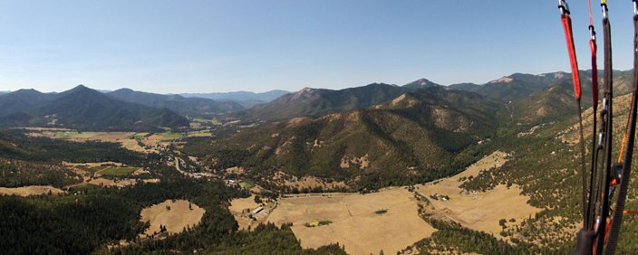
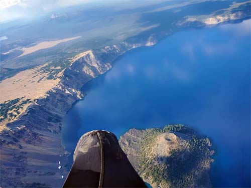
Michael Zanger flying at The Whaleback in July 2010

The Whaleback, located just north of Mt. Shasta on the Klamath National Forest, is an out-of-the-way flying site known for excellent evening flying and cross-country potential.

Flight type(s): Thermal, XC, Glass-off
Season: Summer & early fall (when access road is clear of snowpack)
Glider Restrictions: “Speed” or “mini” wings are not recommended.


Pilot proficiency:
USHPA P3/H3 minimum ; P2/H2 only under appropriate conditions with mentor or instructor present. Flat slope launch (FSL), cliff launch (CL), high altitude (HA), and turbulence (TUR) special skill endorsements are recommended for all pilots.
Membership requirements:  USHPA and RVHPA memberships are requested but is optional.
Launch: 41.534, -122.153 (41° 32.118’N, 122° 9.156’W); Elev. : 7437 ft. (2267 m.); Flat slope launch on gravel.
Wind direction(s) and speed for Whaleback: 260 to 300 degrees.   3-14 mph for paragliders  10-20 mph for hangs.Ideal windspeed is 7 mph for paragldiers and 10 mph for hangs. Ideal wind direction is straight in.
Primary LZ: 41.5505, -122.2 (41° 33.030’N, 122° 12.000’W); Elev.: 4480 ft. (1364 m.); GR: 4.8
Radios & Communication: Local frequency is 151.505 MHz; cell service is good on launch but variable in LZ depending on carrier.
Emergencies: Dial 911.
Access: 2WD accessible via US highway, paved and dirt US Forest Service roads (after snowpack has melted).
Airspace & Air Traffic: No airspace restrictions in immediate vicinity; sail plane traffic is common in the area and over launch. Klamath Falls airport and military operation areas along XC routes have airspace restrictions and/or possible military air activity, including fighter jets.
Landing Restrictions: Landing in the Lava Beds National Monument is prohibited and you may be arrested and have gear confiscated. Do not land in crop fields.
Weather hazards: Over development, cloud suck, strong desert conditions, dust devils, thermic LZ, high winds, density altitude.
Weather info: NWS Forecast for LZ, SoarCast, Grass Lake webcam

More info: ParaglidingEarth, Leonardo

RVHPA site contact: email coming soon; you may also post inquiries to RVHPA1@gmail.com or to RVHPA Google groups 

Rules & Regulations

Pilot Rick Ray launching on the first flight taken from the newly completed Whaleback launch, July 27, 2011.
Pilot Rick Ray launching the first flight taken from the newly completed Whaleback launch, July 27, 2011.

The Whaleback launch and primary LZ are both located on public Klamath National Forest lands and all National Forest rules and regulations apply. Smoking outside a vehicle is not permitted during periods of high fire danger (which is essentially the entire flying season here so please don’t smoke outside). A fire permit is required for any campfire or camp stove use in the area year-round.

Please drive slowly and attentively on the way to launch and LZ. Backroad traffic may be heavy during logging operations, firewood cutting season, and in fall during deer hunting season.

Flying The Whaleback

Welcome to The Whaleback flying site. In the interest of preserving this remarkable flying site and to promote safe flying, we have prepared this  guide to assist pilots in getting the most out of their time at The Whaleback. It is no substitute for a thorough site introduction from a knowledgeable pilot. As always, use your own judgment in determining whether it is safe or appropriate for you to fly the site under current conditions. If you are unsure, do not fly.

Conditions

XC flight eastward from The Whaleback, July 2010.

The Whaleback is an inland high altitude, high desert flying site that has changing weather conditions throughout the day and is often very strong and demanding. A typical day begins with calm conditions in the early morning, increasing thermal development and accompanying winds during late morning, and well-developed thermal cycles by noon. Early afternoon brings on even stronger conditions, cumulus cloud development, and shifting wind gradients. Mid afternoon conditions can be very strong and turbulent, even if winds are relatively light on the surface. By late afternoon thermals begin to lose strength and winds usually slow by mid-evening evening, often making for smooth evening flying suitable for pilots of all skill levels. Winds often go catabatic in late evening.

The Whaleback often overdevelops, sometimes forming cumulonimbus clouds fairly early in the day. This tends to happen during periods of hot, stable weather when an upper level cold front has moved into the region and during periods of monsoonal flow. South winds often accompany this weather pattern which may persist for several consecutive days. Keep an eye on the sky and know the detailed forecast before flying when over-development is a possibility. Early clouds and south winds are a warning sign.

Pilot Proficiency

Landing in the improved LZ with The Whaleback rising in the background.

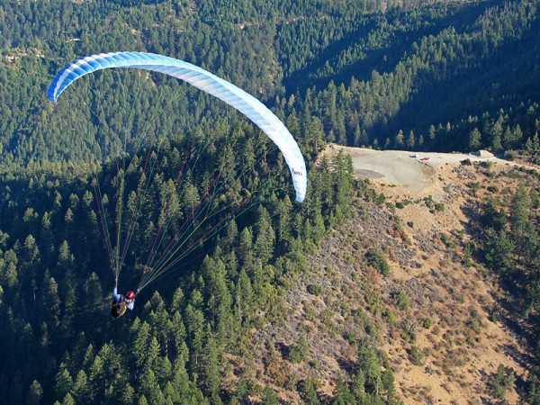
In general, The Whaleback is an intermediate to advanced level site. One of the keys to flying The Whaleback is to match your skills to the time of day with appropriate weather conditions. Novice-rated pilots (P2/H2) should only fly The Whaleback with an experienced mentor who can help evaluate conditions and all novice pilots should avoid mid-day flying altogether. Most often, The Whaleback is suitable for novice pilots only in the early to mid-morning and in the evening after thermals have weakened and winds have backed off. Even with the recent LZ expansion, novice HG pilots may find it on the small side and novice PG pilots may find it a test of skill to land in a grassy area.

All pilots flying in late morning and noontime are advised to monitor changing conditions as peak heating begins. Conditions suitable for intermediate pilots can quickly strengthen, leaving intermediate pilots flying in advanced conditions. This is a particular concern for landing as the small LZ heats and becomes increasingly thermic and windy. Advanced pilots will often find conditions suited for XC flights in the afternoon but, like all other pilots, need to be aware of evolving conditions. The Whaleback commonly overdevelops during sustained periods of high pressure, monsoonal flow, or post-frontal activity, even more so than surrounding peaks.

Launch & LZ

The new Whaleback launch on its first day of use after construction, July 26, 2011.
The new Whaleback launch on its first day of use after re-construction, July 27, 2011.

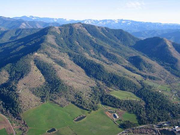
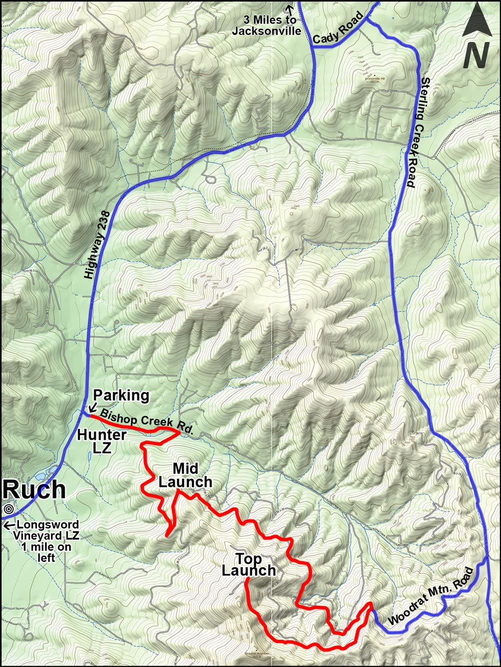
The  launch works with NW to SW winds. The launch is a fairly flat slope with a steep drop-off: essentially this is a flat slope  launch and all pilots must have the requisite skills and experience before launching here. All pilots must be able to fly off the top of the launch area without running down the drop-off. The launch is at 7437 ft. (2267 m.) MSL, making this a high altitude launch that is also greatly affected by density altitude (which often exceeds 10,000 ft. [3049 m.] equivalent). Flying on south wind days is not recommended. On these days, consider flying Herd Peak on the other side of Highway 97 from The Whaleback. East winds are over the back and should not be flown.

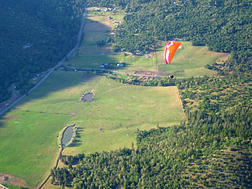
The primary LZ is visible from launch. Look for the rectangular clearing to the NW between launch and Highway 97. It is a 5:1 glide to the LZ and winds often become stronger as you descend closer to the LZ. Depending on wind direction, a pronounced wind gradient and turbulence may be encountered as the wind rolls off the tall treeline immediately SW of the LZ. Landing in the sagebrush short or long of the LZ is usually uneventful, however a few rocks are hidden amongst the bushes.  All roads on the northeast side of Military Pass Road are closed to driving from August 15 to March 1. If you land out here, you will need to walk out to the Military Pass Road.

Parking is very limited at both the LZ and launch. Please carpool efficiently to launch and tightly park vehicles head-in at the parking area on the left as you arrive at launch. Please do not parallel park because this will restrict other vehicles from being able to park in the limited parking area after you. The parking area holds six vehicles on the launch, even fewer at the landing zone without parking on the shoulder of the road. Do not drive or park by the launch slope or layout area and do not block the roadway at either the launch or landing zone, even temporarily.

Cross Country

The Whaleback is a common launching point for XC flights, most of them heading north or northeast. Unless your route follows Highway 97, you’ll probably be flying over very remote and unforgiving forest, mountain, and lava terrain, much of it without easy (or any) road access or cell service. Detailed knowledge of flying routes, landing areas, and road access is essential to avoid long hikes out and/or an unintended night camping beneath your wing–this point cannot be overstated.

Pilots who regularly fly XC at The Whaleback carry maps, a GPS, a SPOT or other satellite location tracker, extra water, food, spare batteries, a headlamp, and enough clothing in the event they spend the night out before being retrieved. A supplemental oxygen tank is a good idea in July, August, and September as cloudbase is often over 14,000 feet (4300 m) MSL.

Mobile phone coverage is limited to a narrow corridor along Hwy 97. Cross country flights and retrieval vehicles following cross pilots cannot assume that there will be mobile services away from the immediate vicinity of Hwy 97. Radios and satellite trackers, Spot, Inreach are crucial in being able to communicate for safety and retrieval. It is not uncommon, even with radios to lose line of sight communication with the pilot or chase vehicle. Xc pilots are encouraged to obtain their FCC ham license in order to be able to access local repeaters in the area. Chase/ retrieval vehicles will frequently need to stay within the mobile access corridor until the xc pilot has signalled a landing or help needed signal. That allows the chase/retrieval  access to  xcfind or xctrack mapping locations. 

Landing in the Lava Beds National Monument is prohibited and pilots may be arrested and have gear confiscated. It is up to pilots to know the monument boundaries and ensure that they are able to fully clear the monument before attempting to fly over it. Do not land in crop fields anywhere along XC routes. Sailplanes and military aircraft are frequently encountered along XC routes and near The Whaleback.

In short, The Whaleback is an advanced XC site and all pilots interested in flying XC here should carefully study maps, planned routes, and alternate routes. First time Whaleback cross country flights should be made with an experienced Whaleback XC pilot. This is not the place to try your first XC flight! All XC pilots and retrieve drivers should have the following paper maps: Klamath National Forest, Modoc Country, and Upper Klamath Basin. The DeLorme California Atlas & Gazetteer is very useful for retrieve but should not be relied upon exclusively. The BLM Lakeview District map is key for those really long flights northeastward.

Other

There are no amenities at The Whaleback. The nearest towns and services to the LZ are Weed (14 miles / 23 km south) and Macdoel (25 miles / 40 km north), both on Highway 97. Gas is also available along I-5 at Grenada and on Route A12 at Big Springs. Arrive at The Whaleback with a full tank and all the other supplies you will need for your visit.  Yreka, Weed, and Mount Shasta have full services, stores, motels, etc. The Deer Mountain Snow Park is on the way to launch and has a pit toilet, picnic tables and pavilion, BBQ pits, and a forested camping area but no water source.

Getting to The Whaleback

Lat/Long: 41.534,-122.153

Lat/Long: 41.5505,-122.2

The Whaleback is the first broad peak rising to the north of Mt. Shasta, about 15 miles north of Weed, CA on US Highway 97. The primary LZ is located a little more than ½ mile east of US Highway 97 on Military Pass Road. Look for a small parking area on the northeast (left) side of the road. A short trail leads to the LZ, which is not readily visible from the parking area. To reach launch from the LZ, return to Highway 97, go north two miles and turn east onto Deer Mountain Road (Forest Road 19). Follow this paved forest road past the Deer Mountain Snow Park then turn right onto dirt road 42N24, six miles from Highway 97. After 3.1 miles on 42N24, turn right onto unsigned road 42N24A and go 1.6 miles to the launch area. It takes about 35 minutes to drive from the LZ to launch. The road to launch is blocked by snowpack for much of the year but can usually be reached by late June or early July. It is usually snowed in again by early to mid-November. Every year is a bit different. 4WD trucks may be needed if patches of snow and ice remain, otherwise 2WD cars can reach launch. Parking on launch is extremely limited and space to turnaround is tight. Please carpool efficiently to launch and park tightly head-in in the designated parking area. Do not park by the launch slope or layout area.

Support The Whaleback Flying Site

RVHPA spends considerable effort and money to insure, maintain, and enhance The Whaleback flying site. Please support this work by becoming a member of RVHPA or by making an quick online donation.

Site History

Josh Cohn launching The Whaleback in 1991.

Legend has it that sometime around 1989, local area paraglider pilot Jim Yates flew from Herd Peak to The Whaleback and identified a potential launch site while thermalling higher and higher. The rest is history: pilots have been enjoying amazing flights from The Whaleback for 20 years.

In the early days, pilots launched from a small, carpeted strip surrounded by brush. The carpet can still be seen in the bushes southwest of the new launch. In the mid-90′s, a local club, the Northern California Foot Launched Pilots Association, built the current launch and kept a small LZ cleared below. It was suitable for paragliders but the relatively few hang glider pilots who flew The Whaleback preferred making it a couple extra miles to land in the (then) larger Herd Peak LZ. Between the mid-90’s and 2009, The Whaleback flying site was not regularly maintained. Sagebrush overtook the LZ, shrinking it to the point that it became a deterrent to flying The Whaleback for many pilots. Use of the site slowly declined but a core group of Shasta Valley pilots and a few RVHPA members continued flying there fairly regularly.

In late 2009, the Rogue Valley Hang Gliding & Paragliding Association, the current stewards of The Whaleback flying site, initiated The Whaleback Site Improvement Project with the goal of making The Whaleback a safer, more user-friendly site. With assistance from the Klamath National Forest in October 2009, RVHPA cleared the LZ of brush and enlarged it twenty-fold, making it safer and more accessible for all pilots of all skill levels. We planted native grass two years in a row to help make a grassy oasis amongst sagebrush flats. It will become greener as the grass takes hold.

RVHPA completed Phase 2 of The Whaleback Site Improvement Project in July 2011, expanding the launch to face a 90 degree window, adding a setup area, expanded parking and a vehicle turnaround. Hazard trees around the LZ were removed in August 2011. For more info on this amazing project, please see The Whaleback Site Improvement Project page.

In summer 2023, the Klamath National Forest cleared brush from the Military Pass Road landing zone as part of a project to create ground disturbance that benefits the endangered Cooke’s phacelia wildflower as well as free flight pilots who land there. The clear area of the landing zone was enlarged slightly in the east-west direction.

Site Records

Hayden Glatte set the current paraglider site open distance record on July 17, 2018 with a flight ending southwest of Badger Mt. Nevada (143 miles / 230.5 km). Details of the current hang glider site distance record are a bit murkier: a pilot is rumored to have made it to the Klamath Falls area in the 1990’s (approx. 40 miles / 64 km). The site altitude record is 17,999 feet (5486 m) MSL, set by paraglider pilot Brian Kerr in 2004.

Board of Directors

Click here for members’ emergency contact list

The RVHPA Board of Directors are comprised of the current year officers, as well as the officers from the previous  2 year term.

2024 RVHPA Officers 


President –  Summer Barham – President2023@rvhpa.org (408) 596-1179
Vice-President –  Justin Caprari – VP2023@rvhpa.org  (541) 488-6484
Secretary – Tonia Fox – secretary@rvhpa.org  (510) 427-2803
Treasurer – Steven Carter – treasurer2024@rvhpa.org  (218) 248-0118
Flight Safety – Boaz “Bala” Ramos – safety2024@rvhpa.org (267) 243-2313
Director at Large –    Rick Ray – 2021dal@rvhpa.org     (541) 326-1214

2022/2023 RVHPA Officers

President –   Terri Stewart- president2019@rvhpa.org (541) 778-2937
Flight Safety -Norm Young – safety2023@rvhpa.org (541) 450-9462
Treasurer – Dan Wells – treasurer2014@rvhpa.org (503) 804-1077


Club History

RVHPA and Woodrat Mountain History

Early Woodrat Mtn. top launch viewed from the old knoll before quarrying lowered it to the elevation of the current top launch. Photo provided by Russ Camp. Date unknown.

RVHPA began in 1977 as RVHGA, the Rogue Valley Hang Gliding Association. The small group of local pilots that formed the club put on the first Starthisle Fly-in in the spring of 1977 at the primary flying site of the day, Medford Baldy. Woodrat Mountain wasn’t flown until 1978 and it took several years for it to catch on as a popular flying site. The club, now named the Rogue Valley Hang Gliding and Paragliding Association, is composed predominantly of paraglider pilots and remains a close-knit and inportant organization for free-flying in Southern Oregon and Northern California. RVHPA now stewards two world-class flying sites, Woodrat Mountain near Ruch, Oregon and The Whaleback near Weed, California. The stories and photos below tell some of the early history of flying at
Starthistle and Woodrat.

The TRUE Starthistle / Woodrat Story

Article & Photos by Bill Shaw

The Gathering

Photo taken at top launch in March 2001 from the location of the old knoll that had been quarried away over 25 years.

For a quarter of a century, foot launch aviators have been flocking to Southern Oregon to partake in the flying, fun, and fellowship of the Rogue Valley Hang Gliding Association’s Annual Starthistle Meet / Fly-in. After all these years, some of the faces, occupations, locations and partners are sure to have changed. And man, have things changed! In fact, all of us originals, (but one) some how fell out of hang gliding, (How the blazes did that happen?) However, recently, a few of us have been returning. So what better time for a reunion, a “GATHERING”, of the original Rogue Valley Hang Gliding Pioneers. So the word is out, and the gathering is on!

The Fearless Leaders

Before we continue any further, I am compelled here to mention two men, who, without their dedication, leadership, and example, there simply would not be a Starthistle Meet, an RVHGA, or even a Woodrat flying site. (Well, okay, maybe someone would have eventually discovered it… but then again…) These two might not have been the first to fly hang gliders in the Rogue Valley, (we’re still researching that) but any other way you look at it, Jeff Van Datta and Doug Hildreth would unequivocally have to be considered the “Fathers of Southern Oregon Hang Gliding”.

The slot launch at Woodrat's "official" opening on April 8, 1978. Clockwise from front- Tom Anderson's Dragon Fly, Paul Nichol's SST, Bill Shaw's Firefly, Steve Bissett's Firefly, Doug Hildreth's Cirrus 3, Leonard Leslie's Olympus.
The slot launch at Woodrat’s “official” opening on April 8, 1978. Clockwise from front- Tom Anderson’s Dragon Fly, Paul Nichol’s SST, Bill Shaw’s Firefly, Steve Bissett’s Firefly, Doug Hildreth’s Cirrus 3, Leonard Leslie’s Olympus.

As the first RVHGA president, and operator of “Superfly Hang Gliding”, Jeff Van Datta was the first and only certified instructor in the valley. While Doug’s insightful maturity helped us organize, and find our direction. This created, for us early pilots, a dependable and safe environment in which to learn to fly, hone our skills, and acquire knowledge. Quite unlike the prior experiences that a few of us had.

For many of us, Doug and Jeff were our mentors. To all of us, they were our flying partners. Then to some of us, they were the greatest of friends. Clearly, these two together were the spearhead of organization, instruction, safety, direction and alliance. They set the example with a committed spirit, that turned out to be contagious. It resulted in a bond among the Rogue Valley pilots, of that time, that I’ve yet to see the equal of anywhere since. However, it is quite clear to me that it is that very same spirit (even after all these years) that lives on today in the notable camaraderie of the RVHGA. That, after all, is the reason for the clasped hands in the logo. (Which, by the way, was a collaborative effort with input from and approval of the club, but specifically designed and put to paper by Steve Bissett.)

By Any Other Name

Okay, the true story huh? If you hang glide in Southern Oregon you are likely far too familiar already with the plant we call starthistle. The thistle is a nasty multi-prong thorn looking something like a pointed pick-up jack. Actually it’s nearly identical in shape to an ancient Ninja weapon made of metal. These were tossed by the hand full to the ground, for various effects including to discourage pursuit.

The Starthistle Fly-In gets its name from this memorable, thorny plant which is a noxious weed introduced to the Western US from the Mediterranean region.

Amazing, isn’t it, that such a fragile piece of plant anatomy can pierce thick levis, jackets, flight suits, shoes and gloves. If you haven’t picked ’em out of your hide yet… you will. If I recollect correctly, 25 years ago, they were mostly in the southeast portions of the valley. Now they seem to be everywhere we fly. Hmmmm…

Northeast of Ashland on the lower flanks of Grizzly Peak was our 50′ “Ashland Training Hill” and about a 1/4 mile southeast of that was “Starthistle” our 150′ intermediate hill that was blanketed with the prickly plants. Continuing in this theme was the “Starthistle Bowl”, a 500′ first altitude site directly south of the training hill.

Since I didn’t start flying with the RVHGA until August of 1977, I was not involved in choosing the name, but after a few conversations with those that were there, it is as one would assume. The plant’s undeniable presence was the main inspiration, with a bit of the essence of the “stars” in the sky. Besides, it does sound and look pretty cool, don’t ya think?

A Starthistle is Born

On April 30th and May 1st 1977, the very first Starthistle Hang Gliding Meet was held at Medford Baldy, located east of Phoenix. (We called it Medford Baldy, to distinguish it from Grant’s Pass Baldy) Medford Baldy is an 1800 ft vertical descent site and, as the name implies, pretty much lacking vegetation, other than starthistle of course. The LZ (which was just across the street from Doug’s house) also had plenty of starthistle.

With hang gliding being so new, back then, there were two primary motivations for the meet. To better acquaint the other “out of the area” Northwest pilots with our flying sites as well as ourselves, and to give the public an “up close and in person” educational experience about hang gliding.

April 8, 1978: Jeff Van Datta Launching the slot on his UP Spider.

The competition was held in five rounds: three rounds on Saturday and two on Sunday. The tasks consisted of max L/D to gates, figure 8 turns made through the gate at minimum sink, and a target landing. The flight score consisted of all tasks including landing. Helmets and rating cards were required, but not parachutes. You see, parachutes for hang gliders wouldn’t work. “They would just get tangled in the wreckage…” that is until someone figured out the deployment bag (sometime in ’78, I think). Man! you talk about thorough preflights! In those days (and even after chutes) pilots with gliders with half the complexity of today’s ships would spend twice the inspection time that I see now days.

Even though the weather really didn’t cooperate with us (does it ever?) on that first event, we had 40 pilots in attendance from as far away as San Francisco. So the word was out, that the Rogue Valley has “some of the best flying in the state.” Guess some things just don’t change.

Registration fee was $5, Spectators $1 and families $2. With this, our receipts were as follows:

  • Registrations $90
  • Concessions $312
  • Admissions $200
  • Beer Garden $200
  • TOTAL: $802 – Expenses $514 = $288 Net (1977 Dollars)

Enter The Rat

Hiking to the Slot "official" opening. Left to right Steve Bissett, Jeff Van Datta, Doug Hildreth, Leonard Leslie, Ken Hill. Bill Shaw took the photo.
April 8, 1978: Hiking to the Slot “official” opening. Left to right Steve Bissett, Jeff Van Datta, Doug Hildreth, Leonard Leslie, Ken Hill. Bill Shaw took the photo.

In late March of 1978, virtually all flights had been sled runs for months. On one particular day we flew sleders off Medford Baldy. The weather was fair (mid 60’s and clear) and not likely to produce anything better, so we decided to check out the Applegate Valley. The trek included Jeff Van Datta, Doug Hildreth, Steve Bissett, Ken Hill, and Bill Shaw (that’s me). We had in mind checking out a few sites Jeff and Doug had found on the maps. In particular was Tallowbox, it really looked impressive on the topos and more impressive in person from the top. Thinking back, we were standing there towering over the valley as we discussed how it might be flown and how to get around the trees if you didn’t get up, and of course getting permission to build a ramp to make it launchable.

Before too long, attention drifted… there at the very east end of the valley was an unobstructed mountain face. A layout much like the famously consistent, Dog Mountain in WA (but without the lake). Well, it sure wasn’t as high as Tallowbox, but it was positioned at the end of the valley and facing pretty much west. So we decided to head off to check it out.

I still remember our rigs (gliders atop, just in case) parked along Hwy 238. As we stood there, surveying the setting, involuntary remarks soon uttered forth. “Oh Man!” … “Look at that!” … “That’s gotta work!” Then, as we gazed upward at the mountain, we each started pointing out clearings that could be potential launch areas. Suddenly, someone said “Wait! Is that a Road?” The unison response, “WHERE?” … “At the top of the clearcut.” Out came the maps, and we were on our way. Up to Cady Road, back track south, then west on the BLM road up the back.

March 28, 1978: Bill Shaw Launching the slot on his UP Firefly.

Cresting the summit and taking in that awesome view for the first time… Well, how would you feel? Besides the view, we’re talking about a 2-wheel drive, BLM road! On BLM Land! Steep! Over 2000 ft vertical descent! Unobstructed! Wind right down the valley and straight up the face! (although there wasn’t much of it that day) And top it off with a whole valley of potential LZ’s!

I’m not sure just when the name of the mountain was first read off the map, but I do remember a distinct vibe of mutual disappointment at the sound of “Wood – Rat”. I’m sure we were all kind of hoping for something really cool sounding – like Cougar Ridge, Talon Peak, or Thunder Mountain… But, Wood – Rat? Gimme a break! Course, we eventually got used it. And now, it’s one of the fondest sounds in my memory.

First Flights

The current launch area on the north end of the west face, was not usable back then due to a single towering tree out front. It effectively obstructed any safe flight path. After looking everything over and picking out alternate LZ’s, it was decided that Doug and Jeff would launch from the clear cut road (actually, I think it was a burn). It was nearing evening with barely a breeze. There was only room for maybe three steps, slightly uphill, before a near cliff drop off with stump / brush obstructions to clear. Tricky launch indeed. Steve and Ken chose not to fly. I had only one cliff launch under my wings, so it was “suggested” that I not fly. Man, I really wanted to though and I’m still sure I would have made a successful launch. But with such little wind and not a clear drop, Jeff and Doug weren’t “sure”. So, with respect for their judgment and more importantly, their sincere concern for my well being – I bit my tongue and didn’t fly. Drats! But still, I was there! Jeff was the first to launch, followed a few moments later by Doug.

Thereafter, the clear cut road was only sporadically used as a launch. Steve Bissett located a slot in the trees to the far south end of the west face with a 40 degree slope. So, we cleared a trail (to carry gliders through) off the end of the clear cut road through the brush and up the hill to the slot. This became the first “official” launch.

So, for all of those keeping track of this kind of thing, the day of the first flight off of Woodrat Mountain was Sunday, March 19, 1978. It was flown by Jeff Van Datta on a UP Spider and by Doug Hildreth on a Cirrus 3. Then, on Tuesday March 28, 1978, Woodrat was flown for the second time (first time from the slot launch) by Bill Shaw and Steve Bissett both on UP Fireflys. The “official” opening of Woodrat was on Saturday April 8, 1978, after LZ permission was secured. That day we had 8 pilots fly from the slot: Jeff VanDatta, Doug Hildreth, Bill Shaw, and Steve Bissett had their second Woodrat flights, while Ken Hill, Leonard Leslie, Tom Anderson, and Paul Nichols had their first Woodrat flights.

Then two days later, on Monday, April 10, 1978, Ken Hill was celebrating his birthday with a picnic on the newly discovered site. The wind picked up, so naturally he had to fly. This flight gave Ken the distinct honor of being the first person to ever soar Woodrat, and on his birthday no less. He flew for about an hour with a max altitude gain of 1600 feet. His log noted “got really choppy away from the mountain”. Like I said, some things just don’t change.

Doug Hildreth Launching the slot on his Cirrus 3, April 8, 1978.

The “slot” launch was relatively short lived though. Mysteriously, one day, the lone tree obstacle was only about half as tall as it had been. From then on, and continuing throughout multiple terrain changes, the north end has been the launch site of choice.

According to Bill Shaw, these are among the first pilots to ever fly Woodrat:

  • Jeff Van Datta, 3-19-78
  • Doug Hildreth, 3-19-78
  • Steve Bissett, 3-28-78
  • Bill Shaw, 3-28-78
  • Leonard Leslie, 3-28-78
  • Ken Hill, 4-10-78
  • Dave Palmer

Just Another Mountain

Believe it or not, Woodrat didn’t catch on all that quickly. Probably because we had several sites that were pretty well developed and were closer to where people lived (in Medford and in Grants Pass). In the months to follow we flew a lot, usually as a group, and mostly elsewhere. For the most part SW Walker, Medford Baldy, and Grants Pass Baldy were our mainstays. Also, after checking my log book, I notice that in the following months through that summer we made 4 trips to the Coast, 2 trips to Eastern Oregon, and started flying Tallowbox.

The Devils Triangle

Then there was another element to consider, the original Woodrat LZ. It’s still there, looking about the same now as it did then. Same downhill slope toward the same power lines. The tree line and tree height is still about the same. Stop and check it out next time. It’s the last clearing on your left as you head east up Bishop Creek Rd. On approach, it feels like it should be called the Devil’s Triangle! Even with the less performing single surface ships of the 70’s it took a bit of skill, but it was the only place we had permission for. Oh ya, another deterrence was the turnaround. Back in the 70’s, Bishop Creek Road didn’t go all the way through and wouldn’t get you to the top. So at first, Woodrat was just another site.

World Class

One young pilot that taught us a bit about Woodrat’s potential and consistency, was actually a transplant from Alaska. He moved to the Rogue valley to attend college in Ashland… and to FLY. He had visited here to check things out before enrollment. I guess no other colleges he was interested in had better flying than the Rogue Valley. I remember that about the only place he seemed to fly was Woodrat. Even when the consensus was that conditions would be better elsewhere, we’d often hear he had gone to Woodrat and done better. He was tenacious about finding lift. He would often stretch the envelope a bit and, as far as I know, he never had even a close call. Could it have been talent? I remember he wanted desperately to somehow make his living from hang gliding. And as we hoped he would, he did! His name is Mark Bennett, the world class competition pilot. Over the years, he has been a factory pilot for most of the major manufacturers and has been a regular top finisher in National and World competitions. Another RVHGA’er makes good!

Meanwhile Back At The Starthistle

The Second Annual Starthistle was held on June 17th and 18th, 1978, with 44 pilots. Followed naturally with the Third Annual Starthistle held June 16th and 17th, 1979. So the first three Starthistle Meets were held at Medford Baldy and were actually pretty large spectator events. We used to get a donation of a buck or two for admission.

Then by 1980 two things had transpired. The Hunters had given us permission to use the large field (the current LZ), and access permission for Medford Baldy, which had always been a battle, was nearing impossible. So now, the only other place that made sense for a meet was, Taa Daa… Woodrat! That brought the Starthistle Meet to Woodrat for the first time on July 12th and 13th 1980. Notice we didn’t hold the meets on Memorial Day weekend. In those days, we saved the 3-day weekends for our Eastern Oregon “Thermal Hunts”! Yep, the very same RVHGA pilots that located and developed Woodrat, were also the early pioneering pilots of the Lakeview area. But that’s another story.

The first Starthistle was held in 1977. The Starthistle Meet isn’t called Woodrat because it was first held at Medford Baldy, (which is really in Phoenix). Not the Grants Pass Baldy, (which is in Grants Pass). The Starthistle Meet was never held at Starthistle even though there were two sites named Starthistle, just like there were two sites named Baldy. In 1980 the Starthistle Hang Gliding Meet (but not the spectators) was moved to Woodrat which didn’t have starthistles. But it’s all okay, because NOW it does, and everyone flies with a parachute. So I guess some things don’t change, while others do. I wonder what else will change, and what will stay the same? How about if we all meet again for the 50th Starthistle and see. Shall we?


Dave Baleria:

The original RVHGA logo.

“Craig Cox, who flew as a youngster. I recall hearing that he flew every single day for four months straight one year. His family lives/lived in the house to the north of Bishop Creek, just off Hwy 238. Also, Craig Cox holds the Woodrat duration record, something like 8 hours, 30 minutes.

Dr. Doug Hildreth might know, as he was one of the very first pilots in Oregon and the RVHGA.

I started in 1985. Rodger Hoyt started before me though. Joseph Bova, Terry Tibbetts, Patti Tibbetts, Jeff and Vicki Jernigan, Mike Patten, Doug Hildreth, Mark Holiday, Craig Cox, Jeff Van Datta, and more – all RVHGA pioneers, hard workers, all pilots.

Fred and Claudia Stockwell, pioneers in PG in the U. S., likely first paragliding flyers. They used to/still live in Rogue River. Wes knew another bag winger years ago, flying Squires Peak. French guy as I recall.”


10-17-1993

Pete Reagan and Tina Pavelic flew Woodrat, with Steve Roti driving. All are from the Portland area. No specific flight reports available. But we are guessing it was good then, too.


RVHPA membership required to use primary Woodrat LZ’s

Pilot Rick Ray landing in Hunter LZ at Woodrat Mountain. This privately-owned LZ is crucial to flying at Woodrat Mountain and RVHPA works hard to maintain this amazing site.

RVHPA has two different levels of membership:

* Visiting Pilot Annual Member– $35 online
* Local Pilot Annual Member– $85 online

Please see the Join RVHPA page for detailed information on joining or renewing your RVHPA membership.  You can join online.  When you join on line your name will immediately appear on the membership web page. When you join online, you can request that we mail you a site pass and helmet sticker.

 Where does the membership money go?
Membership funds  pay for maintaining windsocks in the greater Woodrat area, annual holiday gifts to every landowner whose field we use as an LZ, grading and improving the launch slope, maintaining the parking areas, maintaining the toilet on launch, installing cattle guards on the road, purchasing grass seed for the main LZ, etc.  RVHPA spends thousand of dollars a year to maintain the Woodrat launches and the related LZs in the Applegate Valley.  Any excess funds are invested towards our goal of purchasing a bailout landing zone.

How the Membership Requirement Works
Pilots must be current members of RVHPA and USHPA before using any USHPA insured landing zone’s in the area.  Joining requires completing a membership form, paying dues, reviewing the site guide, and displaying and or providing the proper membership identification. All RVHPA members must also be current USHPA members. This is very important for liability and site insurance purposes.

RVHPA membership is required to legally land in the primary LZ (aka Hunter LZ), use the parking area along Bishop Creek Road, or land in the “feed lot” field on Bishop Creek Road. Those fields and the parking area are private property. The landowners graciously allow RVHPA members to use them. Non-members who use them are trespassing. Please respect this rule and do not trespass on private property.

RVHPA insures the primary landing zones at Hunters Ranch and at LongSword Vineyard.  USHPA  and RVHPA membership is required to land at these sites unless you have prior permission from the landowners.

FAQ on the RVHPA Membership Requirement at Woodrat Mountain

How will RVHPA know if I am a member? All new and renewing annual members will have their rating and membership type show up immediately on the membership page after  completing their online application.  RVHPA club members and officers will be politely if you are a member. The flying community and the club will also sometimes check memberships in the LZ.

The launches on Woodrat Mountain are on public land. How can RVHPA require me to join before launching from land that is freely open to all people? RVHPA membership is not required to launch from Woodrat Mountain, but it is required to land in the privately owned LZs surrounding the mountain and to land in Donato’s LZ Donato, 16km (10 miles) to the east. Every pilot who launches at Woodrat is assuming that he or she will land in the Hunter LZ because it is the only LZ within a guaranteed glide of launch. We can fly at Woodrat only because we are welcomed–as RVHPA members–in the only field guaranteed to be within glide of launch. RVHPA membership is also required to use the privately owned parking area on Bishop Creek Road near the LZ.

I’m a tandem instructor from out of the area and I want to fly a commercial tandem flight at Woodrat Mountain. Can I do that?  Please see Tandem Instructor information here: https://rvhpa.org/instruction/wmic/

I’m coming for the Applegate Open this year. Do I have to join RVHPA? If you plan on flying before , during or  after the event you will need to purchase a membership.

Can I see a list of RVHPA members? Yes. The club keeps a frequently updated current member list on the RVHPA website.

Do I have to be an RVHPA member to fly at The Whaleback? No, but we’d love it if you joined RVHPA anyway as a way of supporting our ongoing work and improvement of The Whaleback flying site.

Updated 11/28/2023
Dan Wells

Tandem Instructional Flights

NOTE: RVHPA is not associated or affiliated with any of the following individuals or companies.  Individuals in the listing are club members acting independently of the club.  The following listing is not a recommendation or endorsement of their services.

Paragliding

Kevin Lee | Thermal Tracker Paragliding

USHPA Advanced & Tandem Paragliding Instructor
http://thermaltracker.com
kevin@thermaltracker.com
+1 541.890.7142

 Sam Crocker | Sundog Paragliding


USHPA Advanced & Tandem Paragliding Instructor
http://sundogparagliding.com
sam@sundogparagliding.com
+1 503.781.1795

Brian Kerr | AirXpansion Paragliding

USHPA Basic & Tandem Paragliding Instructor
https://airxpansion.com/
phone: 1-530-574-7181
Email: brian@airxpansion.com
(Northern California and Shasta Valley)

Hang Gliding

James W. Tibbs | Southern Oregon Airsports
USHPA Basic & Tandem Hang Gliding Instructor
http://www.soair.net
info@soair.net
+1 541.956.9119

Please email the RVHPA Webmaster if you are an RVHPA Commercial Pilot member and would like your name on this list.

Ways to join RVHPA

Our Club

RVHPA is an active community of hang glider and paraglider pilots in Southern Oregon and Northern California.  We maintain several amazing flying sites including Woodrat Mountain and The Whaleback. Membership dues help maintain our flying sites into the future. Please become part our club and fly with us!

Who Can Join

RVHPA membership is open to all USHPA members and is required for all pilots flying at the Woodrat Mountain flying site and using our insured landing areas in Ruch, Oregon. Learn more about this requirement.

Only One Way to Join RVHPA

Join Online

You can only join online . When you join online your membership information goes directly into the member database and can be verified on the members page.  Your emergency contact information is also loaded directly into a secure page that club officers can access in case of an accident.

RVHPA Membership levels

RVHPA has two levels of membership. You will choose your membership level when you join.  Annual memberships are valid for 1 calendar year. However memberships purchased from Sept 1-Dec 31 are good for the following year as well.

Local pilot annual membership $85  Required for all pilots living within 50 miles of Woodrat Mountain launch. Optional for members living up to 75 miles away who would like to support RVHPA and have voting rights. 

Visiting pilot annual membership $35  For pilots living more than 50 miles from launch who do not wish to purchase a local membership.  Required for event organizers and tandem instructors charging a fee for tandem instructional flights. 

Updated 11/28/23
Dan Wells

USHPA Temp Membership required for Foreign Pilots

Foreign pilots (including Canadians) must hold a current USHPA membership in addition to a membership in RVHPA to fly from Woodrat Mountain.

Having the USHPA membership is important because it provides you with liability insurance for any damage you might do to someone’s property.  It is also important because our landowners are not insured against claim by injured parties if the pilot is not a USHPA member.

If you are not a USHPA member you may purchase a 30 day membership from one of the local instructors.  It’s easy…

Just present your IPPI card issued by your country’s free flight governing body to one of the local instructors, complete the 30 day application with the instructor, and sign the waiver on the back side.  The instructor will give you the temporary membership portion of the form and mail the completed form to USHPA.

Typical fee for purchasing this membership  from USHPA through the instructor is  $10 USD.

Local instructors who can issue your 30 day membership are listed below:

Kevin Lee | Thermal Tracker Paragliding

USHPA Advanced & Tandem Instructor
http://thermaltracker.com
kevin@thermaltracker.com
+1 541.890.7142

 Sam Crocker | Sundog Paragliding

USHPA Advanced & Tandem Instructor
http://sundogparagliding.com
sam@sundogparagliding.com
+1 503.781.1795


Woodrat Mountain Site Guide

Last update:
4/14/2024  Dan Wells

Pilot Rick Ray on Top Launch, waiting for a good cycle in March.

Special notes:

The nearest bailout, Hunter LZ is a working cattle ranch and should be treated as such.  Please read LZ rules below.  The Wells Land and the  LongSword Vineyard LZ is a viable LZ options in appropriate conditions.

Note LongSword LZ is only open when their tasting room is open.  See LongSword rules for details 

The launch at Woodrat Mountain is on public land however the bail out and nearby landing zones of Hunter and LongSword are on private land.  By agreement with the landowners a USHPA and RVHPA club  memberships  are required to land on these fields

All instruction (solo or T-1/T-2/T-3) at Woodrat is conducted only with a local sponsorship, sign off, and an RVHPA membership. Contact Kevin Lee at kevin@thermaltracker.com (541-890-7142). See the Woodrat Mountain Instruction committee (WMIC) page for more details.

The Basics

Woodrat Mountain is a beautiful flying site for hang gliders and paragliders. With great weather, excellent XC opportunities, and regular evening glass-offs, it is the primary RVHPA flying site and has a 38+ year continuous history of free flying.

We would not be able to fly Woodrat without the generosity of local landowners that provide us with landing zones and parking areas. Our continued ability to fly here depends on all pilots adhering to the basic rules of the site and desires of these generous landowners.

Please help preserve this amazing site by reading this site guide, getting a site intro, and by following all rules at the mountain. Always check the RVHPA kiosk in the Bishop Creek Road parking area, , or the Site status page on this website for important updates before flying.   Thank you and enjoy Woodrat!

Flight type(s): Thermal, XC, Glass-off
Season: Year-round; best in spring, summer, and early fall.
Pilot proficiency: Top Launch – USHPA P3/H3 required; P2/H2 allowed only with mentor or instructor sign-off. Mid Launch – H2/P2 minimum.
Glider Restrictions: “Speed” or “mini” wings are not permitted to use the Hunter LZ due to concerns on their glide ratio relative to a safe glide from launch to landing.
Membership requirements: Current RVHPA and USHPA memberships required to land at Hunter and LongSword Landing zones.
Top Launch: 42.2317, -123.004 (42°13’54” N, 123°0’14” W); Elevation : 3780 ft. (1162 m.); Gravel slope.  Tiedowns for hang gliders are available along the south edge of the launch area.
 Wind direction(s) and speed for North side Top launch: 330 to 050 degrees.   0-15 mph for paragliders  0-20 mph  for hangs. Ideal wind speed is 7 mph for paragldiers and 10 mph for hangs. Ideal wind direction is straight in.
Wind direction(s) and speed for West side Top launch:
230 to 320 degrees.   0-15 mph for paragliders  0-20 mph  for hangs. Ideal wind speed is 7 mph for paragldiers and 10 mph for hangs. Ideal wind direction is straight in.

Mid Launch: 42.2413, -123.0144 (42°14’28.61″N, 123° 0’51.82″W); Elevation : 2750 ft. (838 m.); grass slope
Wind direction(s) and speed: 210 degrees to 330 degrees. 0-15 mph for paragliders  0-20 mph for hangsIdeal wind speed is 7 mph for paragldiers and 10 mph for hangs. Ideal wind direction is straight in.
Hunter LZ (Hunter Ranch): 42.2471, -123.026 (42°14’49” N, 123°1’33” W); Elevation: 1650 ft. (503 m.); GR: 4.0 from both launches.
Longsword LZ (Longsword Vineyard): 42.2328, -123.0553 (42°13’57.88″N, 123° 3’18.93″W); Elevation: 1460 ft. (445 m.); GR: 6.0 from top launch
Wells Land LZ 42.21754 -123.05055; Elevation 1470 ft. (450m) Glide ratio is similar to LongSword but the LZ is hidden from view at launch by Squires peak.
Radios & Communication: Local frequency is 158.400 MHz (151.955 reserved for instructional use only).  When 158.400 is busy with other traffic 151.925 is often used as an alternate.  Check with other pilots and make a radio check to be sure you are on the frequency being used.
Cell Service: Good on launches but variable in LZs depending on carrier.
Emergencies: dial 911
Access: 2WD accessible via paved and dirt roads.
Airspace & Air Traffic: No airspace restrictions in immediate vicinity. Private plane traffic is not uncommon. Medford airport has class D airspace with a large Class E surface extension to the east.
Weather hazards: Strong valley winds, turbulent inversions, convergence over launch & LZ, concealed S and E winds on launches.
Weather info: Ruch Forecast, Provolt Wx Station, Squaw Peak Wx Station, Longsword LZ Wx Station, Tallowbox Wx Station, RVHPA’s weather links
Waypoints & Google Earth Links: coming soon
More info: ParaglidingEarth, Leonardo
RVHPA Site Contact:  see the RVHPA Google Group to ask a question or arrange a site intro.

Rules & Regulations

If it seems like we have a lot of rules at Woodrat, it is because we do—but they are all based on common sense and courtesy. These rules exist so that we can continue to fly at Woodrat and access the privately owned LZs that are essential to flying here. The magnificent sense of freedom we experience flying here comes at the small cost of following these rules. Please follow them and help us maintain the privilege of flying here.

Hunter LZ Rules

If landing at the Hunter LZ, please land in the currently designated field which is generally whichever field does not have cows or horses.  Pack up and leave the field as quickly as possible after landing and exit via the gate closest to the parking area (not the gate near the cattle chute). Do not loiter on the ranch or on Bishop Creek Road.

The Hunter family has allowed us to land on their cattle ranch for over 40 years! More than anything else, it is their amazing generosity allowing access to this essential LZ that allows us to fly at Woodrat Mountain.

Please adhere closely  to the following specific rules:

  • Only current RVHPA members are granted permission to use the Hunter LZ
  • Be sure to land only in the currently designated field (which changes from time to time–be sure to have the latest info).
  • Observe all Woodrat flying site rules & USHPA regulations.
  • No smoking & no alcohol on the LZ.
  • No dogs on the LZ.
  • No littering. Please pick up any litter you see.
  • No kiting, practicing, or instruction in the LZ.
  • PG: Please deflate your wing immediately after landing and carry it to the designated fold-up area. HG: Please immediately after landing carry your glider to the designated fold-up area.
  • Enter and exit the LZ at the access gate in the lower NW corner of the main field.
  • Pack up quickly, leave the field, and do not loiter on the Hunter Ranch, parking area, or Bishop Creek Road.
  • Keep all gates closed and latched at ALL times.
  • No vehicles inside any gated area or in the LZ field.
  • Avoid walking by or lingering at the cattle chute between the main field and the feed lot.
  • No acro above or near the LZ.
  • No powered aircraft within earshot of the LZ.
  • “Speed” or “mini” wings are not permitted to use the Hunter LZ due to concerns on their glide ratio relative to a safe glide from launch to the landing area.

Not following the above rules could result in loss of this landing zone.

Notes:
In the last few years the Hunter LZ has seen unprecedented stress placed on it.  The Hunter LZ is part of a working cattle ranch and we request pilots and guests treat it as such.  When conditions permit pilots are requested to use other landing zones.   LongSword LZ is an option when pilot skill and weather conditions permit landing at this LZ.  So is Wells Land LZ.  If you are unsure about a rule, ask a RVHPA member or instructor for clarification. Also, please help make sure other pilots are aware of and follow these rules.

Bishop Creek Road Parking Area Rules

In an effort to reduce stress on the Hunter Ranch LZ and parking area, pilots often meet at the LongSword Vineyard LZ  set car pools up to launch. The Bishop Creek Road parking area near the Hunter LZ is on private property adjacent to a residence and is located along a road that local residents use frequently. The landowner has asked us to adhere to these rules:

  • Parking permitted for current RVHPA members only.
  • Park “head in” to reduce risk of fire from car exhausts.
  • No smoking & no alcohol.
  • No dogs outside vehicles.
  • No littering. Please pick up any litter you see.
  • No loud music or noise.
  • Do not block driveways or Bishop Creek Road at any time and do not set gear on or stand in the road.
  • Walk on the shoulder of the road when going to/from the Hunter LZ.
  • No overnight parking.

If the Hunter LZ/RVHPA parking area is full, do not park elsewhere along Bishop Creek Road. Instead, use one of these two options: 1)  park in the designated pilot parking area at LongSword Vineyard (3/4 mile west of Ruch), or 2) head toward launch and at the first pullout along the BLM road (approximately 1 mile from Bishop Creek Road Parking area).

 LongSword LZ Rules

LongSword is a business operation and we are guests whenever we land here. Please be courteous and considerate, just as you would be while a guest in anyone’s home or business–especially in one that grants you the generous privilege of landing there!

  • Visiting pilots must have reviewed these rules and have approval from a local pilot site guide to land at LongSword.
  • All pilots landing at LongSword must be current USHPA and RVHPA club members.
  • Strictly enforced speed limit of 5 mph on gravel road – violators may lose landing privileges on the spot if caught speeding!
  • Use caution to avoid running over geese, chickens and sheep which occasionally block the road. Any pilot injuring an animal will lose their landing rights permanently.
  • Park only in the designated pilot parking area to the west of the tasting room. Do not park in front of the tasting room.
  • Be courteous, polite, and do not swear, curse, or speak at a volume that tasting room customers would find offensive: LongSword is a business with customers present at all times.
  • Alcoholic beverages may not be brought on to the property due to Oregon LCC regulations. Beer and wine are available from the tasting room.
  • If visiting the tasting room, enter the same way customers do and leave the best patio seating for the vineyard’s wine tasting customers.
  • Do not take wings or gear onto the patio area.
  • No smoking is allowed except in the gravel area in front of the tasting room
  • No dogs allowed off leash.
  • No littering. Please pick up any litter you see.
  • The parking area will not open before 11:00 AM and all pilots must be off the LongSword property by 8:30 PM or sunset– whichever is earlier.
  • Do not enter the property when the gate at Hwy 238 is closed without making prior arrangements.

Keep in mind that we are guests that have been welcomed onto their property while they are running a vineyard and tasting room business. We will continue to be welcomed at LongSword as long as we remain an asset to their operation and not an unfortunate problem they have to deal with.

Rules of the Road when driving to launch

Of course, all regular state and federal laws apply to driving on the roads at Woodrat Mountain. Due to the number of driving accidents involving pilots and the number of neighbor complaints about pilots’ driving, please drive slowly, alertly, and courteously at all times! Expect oncoming traffic, pedestrians, dogs, goats, and equestrians at all times. Speed limit is 20 mph.  Head-on collisions do happen on Woodrat Mountain!  Drive safely!

Woodrat Mountain & the Hunter LZ in spring with the snowy peaks of the Siskiyou Crest in the background.


Flying Woodrat Mountain

Woodrat Mountain has two launches, a primary LZ, and several other landing areas within a short distance.

Weather & Conditions

Woodrat can be a very reliable flying site and it is possible to fly most summer days. The best conditions have west, northwest, or north winds. The day or two after the passage of a cold front can be especially good. Spring flying conditions vary but include some of the best days of the year at Woodrat. Summer has consistent high pressure conditions. Early to mid fall is consistently good and has waning wind and lift conditions plus interruptions by the first major frontal systems of the cooler season. Winter days often offer sled rides or boaty flights around the mountain but occasionally give up a flights lasting an hour or more, sometimes over snowy forests.

As an inland thermic site, Woodrat’s flying conditions change during the course of any given day. Typically summer conditions are smooth and without much lift in the morning, lift builds mid-morning, light turbulence and thermals begin, and by noon or shortly later strong thermals and wind have developed. Summer and early fall evenings often have smooth, buoyant conditions and glass-offs are not uncommon but are essentially unpredictable. Wise pilots choose the time of day for conditions that match their skills and desires.

With the Pacific Ocean not too far to the west, marine weather often factors into Woodrat’s conditions. This is often expressed as a layer of stable marine-influenced air that caps the heated valley air below–an  inversion.  These inversions are very common on stable summer days and often occur between 4000 and 6000 feet MSL. Expect varying degrees of turbulence at these inversions and cooler air, possibly with different wind speed or direction above the inversion.

Weather Hazards

Woodrat is not safe to fly on strong south or east wind days due to large-scale rotor. The launches are shielded from south winds so study the forecast and consider using a helium balloon as a wind dummy if there is any chance of all but the very lightest east or south winds aloft.

Woodrat is often directly under a convergence zone of colliding Applegate & Rogue Valley winds.  When this happens, winds on launch and in the LZ may alternate between N and W and/or the wind in the Hunter LZ may be opposite of winds on launch. Be especially cautious in these conditions.

Valley winds may increase rapidly on summer afternoons and during pre-frontal conditions, increasing thermic turbulence in the Hunter LZ.

See the weather page for links and more info.

The Launches

Mid Launch

Mid Launch has two launch slopes, one facing southwest and the other facing northwest at about 2750 feet elevation. The southwest launch is a grassy slope with plenty of width and length. It is often used for launching into glass-offs, especially when the wind at Top Launch is too strong. The northwest launch requires laying out on the gravel road surface and performing a flat slope launch toward a steep drop off. The glide ratio from Mid Launch to the LZ at LongSword Vineyard is about 9:1! 

Please park in the large, flat parking area above the launch slopes.

Pilot Brett Kerin preparing for a Top Launch fly by at Woodrat Mountain in early fall. Photo by Scott Harding.
Top Launch

Top Launch has two launch slopes at 3780 feet elevation, one facing west and the other north.  Both launches are covered in gravel. RVHPA maintains a windsock at the top of a tall fir tree between the two launches as well as numerous wind streamers. Tiedowns are available for hang gliders along the south side of the launch area. The glide ratio to the Hunter LZ is about 4:1, with either the LongSword Winery LZ  being about a 6:1 glide.

The peak of Woodrat Mountain blocks southerly winds from directly hitting launch and may conceal evidence of rotor over the launch area. In fact, south winds may give the appearance of light cycles coming up either the west and/or north launches. Know the forecast winds aloft and be especially wary if there is any significant south component. Some pilots will check winds above launch by releasing a helium balloon on days with potential of south winds.

Landing Zones

Hunter LZ

The Hunter LZ is located at the northwestern base of Woodrat Mountain and has been the primary landing zone for over 30 years. The Hunter LZ has seen unprecedented stress due to overuse and a series of unfortunate incidents involving pilots and should be used with the utmost care and respect.

All pilots landing here must be current USHPA and RVHPA members.

Pilot Chris Ammon over the Hunter LZ.

The Hunter LZ is the only LZ within a 4:1 glide of all launches at Woodrat Mountain, hence its strategic position as an LZ. This property is a working cattle ranch owned by the Hunter family and we need to be aware of the impact that our use of the LZ has on their cattle and livelihood. By all means, land at the Hunter LZ when you need to but, when safe to land elsewhere, please use other landing fields. The LongSword LZ, located just over one mile to the west, is now a frequently used LZ at Woodrat Mountain (see wind warnings).

RVHPA maintains several windsocks in the main field of the Hunter LZ. This may seem redundant but the various windsocks may give valuable information. For example, they may point toward each other when a large thermal is lifting off the center of the field. Or some may point one direction and the others opposite when a convergence line is centered over the LZ. Both these situations are common and require extra diligence for landing in the Hunter LZ. It is often better to fly to Longsword LZ when there are large thermals, convergence, or strong winds at the Hunter LZ. The Longsword Vineyard LZ is often smoother, more uniform, and safer in these conditions.

Please see the rules for using the Hunter LZ.

LongSword LZ  (LongSword Vineyard):

Situated in the main part of the Applegate Valley just west of Ruch at an elevation of 1460 ft. ASL, the  Longsword Vineyard LZ often has the smoothest conditions of any landing field near the mountain.  This is often a wise choice of landing places in mid afternoon when other fields can become extraordinarily turbulent. All pilots landing here must be current USHPA and RVHPA club members.

The Longsword Vineyard LZ is the large flat field just south of the vineyard and east of the tasting room building and is about 10 acres in size. There are windsocks at the northeast corner of the landing field and at the fence line directly west of the center of the landing field.

There is a wine tasting structure and patio in the northwest corner of the landing field. Be aware of the rotor that develops in the lee of the building.

The glide ratio required from Top Launch to the Longsword LZ is about 6:1; from Mid Launch it is a 9:1 glide. Seriously consider whether you and your glider are capable of reaching the Longsword LZ before launching from Mid Launch (or even Top Launch). There is often a headwind between Woodrat and Longsword. A pronounced increase in headwind frequently occurs between Ruch and Longsword, specially in lower altitudes. Factor this in to your decision making as there are few safe places to bail out in the near vicinity of Ruch.

See all the rules for the LongSword LZ.

Wells Land LZ:
N42.21758  W123.05095   Elevation:   1470f ft.

Wells Land LZ is located .9 miles west of Squires peak at the mouth of the Upper Applegate Valley.   It has approximately the same glide ratio as LongSword but is hidden from view on launch by Squires peak.  Conditions there are generally less thermic than Hunters and more similar to LongSword.  Just not as large.  There are three landing areas between 180 to 200 yards in length with each surrounded by fences.  There are two horses that may be present in landing zones 1 or 2.  They are paraglider friendly and will not be spooked by landing pilots.  LZ 3 is usable only if no hemp is being grown there.

Cautions:
In thermic conditions with light winds these landing zones require a higher level of skill than Hunter’s or LongSword.  There is a slight downslope to the north and that coupled with thermals make landing without overshooting more challenging.  Be sure to set up low enough before your final approach to give yourself some margin in case you get popped and end up landing longer than planned.

Also beware that the winds 1000 feet above  the LZ can be much stronger than at the surface.  Always make your initial approach well upwind of the landing zone to check your penetration.  The windsocks are not the best indicators of the wind strength at altitude.

Landing zones: Note that the fence between LZ 1 and 2 has been removed in May of 2022

Wells Land’s street address is just off the Upper Applegate Rd at 118 Hamilton Road.  Club pilots have permission to use the designated parking area for staging rides to launch from mid-morning to dusk.  

Pilot parking area

Cross Country

Although most flights at Woodrat remain in the local area, the mountain has excellent cross country potential in every direction and XC flying is popular here. Common destinations for XC flights include Grants Pass (northwest), Applegate Lake (south), LZ Donato (east), Jacksonville, (north), and Applegate (west). There is Class E controlled airspace to north and east that affects XC flying in these directions; please consult a sectional map and know the location of controlled airspace for the MFR international airport.

Social Hour

Flying at Woodrat is often a social experience as much as it is an aviation experience. There are pilots at the mountain nearly every good summer day. RVHPA members often hold impromptu barbeques at LongSword Winery or Mid Launch in the evening,  spend time swimming in the river mid-day, or get together for lunch in Ruch or Jacksonville.

Getting to Woodrat Mountain

Woodrat Mountain is located eight miles south of Jacksonville and approximately 10 miles southwest of Medford, Oregon along Highway 238.

The Hunter LZ & Bishop Creek Road Parking Area

From I-5 follow the signs to Jacksonville, then continue on Highway 238 (California St.) for 6.5 miles toward Ruch. Turn left onto Bishop Creek Road (if you reach Ruch, you’ve gone one mile too far). Continue 500 feet on Bishop Creek Road and the parking area will be on your left. Please park only in the designated parking area. If it is full, you can continue up Bishop Creek Road 7/10 of a mile, turn right, and park at the large turnout on BLM land 1/2 mile beyond the 3rd cattle guard.

Longsword Vineyard LZ

From the Bishop Creek Road parking area: follow Highway 238 to the small town of Ruch, about ½ mile west of Bishop Creek Road. The Longsword Vineyard is on the left about ¾ mile west of Ruch. Please drive 5 mph on the gravel roads at the Longsword Vineyard and to help keep dust down by going slower when needed.

Wells Land LZ

From the Bishop Creek Road Parking area: Follow Hiway 238 through Ruch and turn left on the Upper Applegate Rd.  Go approx. 1.7 mile to Hamilton Rd and turn right.  Wells land entrance 118 Hamilton drive is 500 feet down the road on your right.

Mid Launch

From the Bishop Creek Road parking area, continue up Bishop Creek Road for 7/10 mile and, at the three-way intersection, turn hard right. Cross the cattle guard and continue uphill on the paved road for 1.5 miles. You will see the sign for Woodrat Mid Launch on your left, 2.3 miles from the LZ parking area. Please park in the upper parking area at Mid Launch and not next to the launch slopes.

Top Launch

Woodrat Road Map
Woodrat Mountain road map with route up front side (red) and back side (blue). Click on map for large version.

There are two ways to reach Top Launch and they both take the same amount of time. Driving up the front side gives you access to Mid Launch along the way but entails more miles of dirt road driving. Going up the back side of Woodrat is paved except for the last two miles and is a good alternative for passenger cars. Expect oncoming traffic at all times on either of these routes and please drive slowly. Carpool to reduce traffic and minimize accident potential.

From the Front Side of Woodrat Mountain (more miles of dirt road)

From the main LZ parking area, continue up Bishop Creek Road for 7/10 mile and, at the three-way intersection, turn hard right. Cross the cattle guard and continue uphill on the paved road. Mid Launch will be on the left 2.3 miles from the LZ parking area. Continue to Top Launch on the paved road; before too long it will become a dirt road. Continue along this road (BLM Road 38-3-23.1), staying right at the intersection that is about 3 miles from the LZ parking area. Continue 1.5 more miles and you will reach top launch, 6.8 miles from the main LZ parking area.

From the Back Side of Woodrat Mountain (more miles of paved road)

From the Hunter LZ parking area, go back to Highway 238 and turn right (north). Continue on 238 for about four miles until reaching Cady Road at Jacksonville Hill Summit. Turn right onto Cady Road and continue 1/2 mile and turn left on Sterling Creek Road. Go 4.6 miles on Sterling Creek Road and, near the crest of a long hill, turn right onto Woodrat Mountain Road. Go 3/4 mile and, at the junction of dirt roads, turn left to stay on Woodrat Mountain Road (unsigned). Continue 1.5 miles to reach Top Launch.

Rides up to launch

There is no organized shuttle to launch.  But there are generally enough pilots flying when the weather is good that you can get a ride.  Pilots genrally meet at the LongSword Winery.  Check the RVHPA Google groups site or Telegram to see who is flying and when they are meeting.  During peak times the “Flying van” may be running which can take up to 10 or more pilots up the hill. The driver generally posts when he is driving.  Please offer to chip in for fuel and wear and tear on the vehicle when getting a ride.  It’s customary to offer $10 for a trip to Upper launch and $5 for a ride to Mid launch.

Site History

Please see the history page for photos and stories from the early days at Woodrat, beginning with the first flights in 1978.

Site Records

The current site record was set by Hayden Glatte on 7/10/2013. He launched  Woodrat and landed 6 hours and 37 minutes later in Bly, Oregon, a straight line distance of 158.4 km.(98.4 miles). Check out the flight on Leonardo.

Destino snapped this picture of Crater Lake and Wizard Island while thermalling over the lake.

Although not a distance record, perhaps the most challenging and scenic flights was made by Destino Stellavem on 8/15/20.  Launching from Woodrat, Destino flew for  6 hours and 15 minutes managing to fly  over Mt. McGlaughlin, Crater Lake, and Mt. Thielsen before landing 135 kilometers (84 miles) from Woodrat near the intersection of Highway 97 and 138 nine miles south of Chemalt, Oregon.  Details are on Leonardo.

Also worthy of note is a 164 km FAI triangle flight by Zion Susanno from Costa Rica on June 19, 2018.  Details are on Leonardo.   Previous triangles flown by local pilots had been less than half that distance.

Details of the record-setting hang glider flight are less clear. Pilot Mark Bennett made a flight to Hilt, California (approx. 25 miles / 40 km) around 1980. This may be the longest distance hang glider flight originating from Woodrat Mountain. Other long flights have gone past Grants Pass, Oregon. Please contact RVHPA if you have information on hang glider site records.

Woodrat Contacts

Please see the RVHPA Google group site to ask a question or arrange a site intro. Or post on the club’s Telegram group “RVHPA Woodrat flying”

Herd Peak Site Guide

Last update:
2/13/2924
Dan Wells

Both the Herd Peak launch and LZ are on private land. A site intro and waiver are required.

The Basics

Herd Peak is an inland desert site located in the Shasta Valley. It has a long history of free flight and is known for its excellent summer glass-off conditions and XC potential. Both the launch and primary LZ are located on private land with permission granted for USHPA member pilots.

Flight type(s): Thermal, XC, Glass-off
Season: Spring, summer, & fall
Pilot proficiency: USHPA P3/H3; P2/H2 with instructor or mentor sign off. Site intro required for all pilots.
Glider Restrictions: “Speed” or “mini” wings are not permitted.
Membership requirements: USHPA membership required; RVHPA membership recommended but not required.
Site Waiver: Required, usually available on launch. We recommend you download and print the waiver. Deposit signed waiver in box on launch.
Launch: 41.6166, – 122.229 (41°36’59” N, 122°13’44” W); Elev. : 5680 ft. (1732 m.); Dirt slope.
Wind direction(s) and speed for Herd Peak: 220 to 270 degrees.   2-14 mph for paragliders  10-20 mph for hangs.  Ideal wind speed is 7 mph for paragldiers and 10 mph for hangs. Ideal wind direction is straight in.
Primary LZ (Sheep Rock Ranch): 41.5825, -122.2559 (41°34’57.02″ N, 122°15’21.10″ W); Elev. : 3495 ft. (1066 m.); GR: 6.5.
Radios & Communication: Local frequency is 151.505 MHz; cell service is good on launch and in primary LZ with most carriers.
Emergencies: Dial 911
Access: 2WD accessible via US highway and dirt US Forest Service roads.
Airspace & Air Traffic: No airspace restrictions in immediate vicinity; sail plane traffic is common in the area. Klamath Falls airport and military operation areas along XC routes have airspace restrictions and/or possible military air activity, including fighter jets.
Landing Restrictions: Landing out in the Lava Beds National Monument is prohibited without prior notification and permission of the National Park Service.
Weather hazards: Over development, cloud suck, strong desert conditions, dust devils, thermic LZ, high winds, density altitude.
Weather info: NWS Forecast for LZ, SoarCast, Grass Lake webcam
More info: ParaglidingEarth, Leonardo
RVHPA site contact: herdpeak@gmail.com; you may also post inquiries to the RVHPA Yahoo! Group.

Rules & Regulations

Flying Herd Peak

Herd Peak launch, Oct. 11, 2009.

Welcome to the Herd Peak flying site. In the interest of preserving this remarkable flying site and to promote safe flying, we have prepared this  guide to assist pilots in getting the most out of  their time at Herd Peak. It is no substitute for a thorough site introduction from a knowledgeable pilot. As always, use your own judgment in determining whether it is safe or appropriate for you to fly the site under current conditions. If you are unsure, do not fly.

Conditions

Pilot Proficiency

Minimum USHPA skill rating for Herd Peak is H3/P3. A H2/P2 pilot may fly only with the approval of a USHPA instructor or mentor.

Launch & LZ

Cross Country

The Herd can be a launching point for XC flights, most of them heading north or northeast. Unless your route follows Highway 97, you’ll probably be flying over very remote and unforgiving forest, mountain, and lava terrain, much of it without easy (or any) road access or cell service. Detailed knowledge of flying routes, landing areas, and road access is essential to avoid long hikes out and/or an unintended night camping beneath your wing–this point cannot be overstated.

Pilots who regularly fly XC at Herd carry maps, a GPS, a SPOT or other satellite location tracker, extra water, food, spare batteries, a headlamp, and enough clothing in the event they spend the night out before being retrieved. A supplemental oxygen tank is a good idea in July, August, and September as cloudbase is often over 14,000 feet (4300 m) MSL.

Mobile phone coverage is limited to a narrow corridor along Hwy 97. Cross country flights and retrieval vehicles following cross pilots cannot assume that there will be mobile services away from the immediate vicinity of Hwy 97. Radios and satellite trackers, Spot, Inreach are crucial in being able to communicate for safety and retrieval. It is not uncommon, even with radios to lose line of sight communication with the pilot or chase vehicle. Xc pilots are encouraged to obtain their FCC ham license in order to be able to access local repeaters in the area. Chase/ retrieval vehicles will frequently need to stay within the mobile access corridor until the xc pilot has signalled a landing or help needed signal. That allows the chase/retrieval  access to  xcfind or xctrack mapping locations. 

Landing in the Lava Beds National Monument is prohibited and pilots may be arrested and have gear confiscated. It is up to pilots to know the monument boundaries and ensure that they are able to fully clear the monument before attempting to fly over it. Do not land in crop fields anywhere along XC routes. Sailplanes and military aircraft are frequently encountered along XC routes and near The Whaleback.

In short, Herd  is an advanced XC site and all pilots interested in flying XC here should carefully study maps, planned routes, and alternate routes. First time Whaleback cross country flights should be made with an experienced Whaleback XC pilot. This is not the place to try your first XC flight! All XC pilots and retrieve drivers should have the following paper maps: Klamath National ForestModoc Country, and Upper Klamath Basin. The DeLorme California Atlas & Gazetteer is very useful for retrieve but should not be relied upon exclusively. The BLM Lakeview District map is key for those really long flights northeastward.

Other

Getting to Herd Peak

Herd Peak LZ, looking back at the mountain and launch. Oct. 11, 2009.
Herd Peak LZ on the Sheep Rock Ranch, looking back at the mountain and launch. Oct. 11, 2009.

Site History

Site Records

Hayden Glatte set the paraglider site record for distance on June 26, 2011 with an 87.8 mile (141.3 km) flight to Alturas, California.